Ōta
太田市 | |
|---|---|
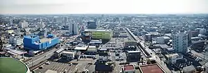
 View of downtown Ōta | |
 Flag  Emblem | |
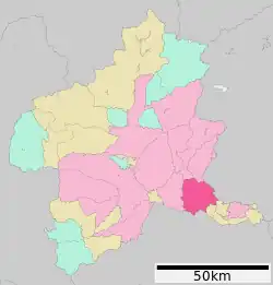
 Location of Ōta in Gunma Prefecture | |
 Ōta | |
| Coordinates: 36°17′28.1″N 139°22′31.4″E / 36.291139°N 139.375389°E | |
| Country | Japan |
| Region | Kantō |
| Prefecture | Gunma |
| First official recorded | 5th century AD |
| City settled | May 3, 1948 |
| Government | |
| • Mayor | Masayoshi Suzuki |
| Area | |
| • Total | 175.54 km2 (67.78 sq mi) |
| Population (August 2020) | |
| • Total | 224,358 |
| • Density | 1,300/km2 (3,300/sq mi) |
| Time zone | UTC+9 (Japan Standard Time) |
| - Tree | Pine, Osmanthus, Maple, Ginkgo |
| - Flower | Chrysanthemum, Sage, Spring orchid, Azalea |
| Phone number | 0276-47-1111 |
| Address | 2-35 Hama-cho, Ōta-shi, Gumma-ken 373-8718 |
| Website | Official website |
Ōta (太田市, Ōta-shi) is a city located in Gunma Prefecture, Japan. As of 31 August 2020, the city had an estimated population of 224,358 in 109,541 households,[1] and a population density of 1300 persons per km2. The total area of the city is 60.97 square kilometres (23.54 sq mi).
Geography
Ōta is located in the extreme southeastern portion of Gunma Prefecture in the northern Kantō Plains, bordered by Tochigi Prefecture to the east and Saitama Prefecture to the south. The city is located 80 kilometres (50 mi) northwest of Tokyo between the Tone and Watarase rivers.[2] It is located about 80 kilometers northwest of central Tokyo, about 30 kilometers east of the prefectural capital at Maebashi, about 40 kilometers east of Takasaki. The elevation of the city ranges from 30–40 meters in lowland in the south, southwest, northeast, and east, to 40–70 meters in the northwest.
Surrounding municipalities
Climate
Ōta has a Humid continental climate (Köppen Cfa) characterized by warm summers and cold winters with heavy snowfall. The average annual temperature in Ōta is 14.4 °C. The average annual rainfall is 1260 mm with September as the wettest month. The temperatures are highest on average in August, at around 26.7 °C, and lowest in January, at around 3.5 °C.[3]
Demographics
Per Japanese census data,[4] the population of Ōta has increased steadily over the past 60 years.
| Year | Pop. | ±% |
|---|---|---|
| 1960 | 127,353 | — |
| 1970 | 141,491 | +11.1% |
| 1980 | 175,381 | +24.0% |
| 1990 | 197,139 | +12.4% |
| 2000 | 210,022 | +6.5% |
| 2010 | 216,465 | +3.1% |
| 2020 | 223,014 | +3.0% |
History

During the Edo period, the area of present-day Ōta contained two post towns on the Nikkō Reiheishi Kaidō, a subroute to Nikkō Kaidō which connected the Nakasendō directly with Nikkō, bypassing Edo,[5] the Ōta-shuku (太田宿), (from which the city takes its name) and Kizaki-shuku (木崎宿).[2]
Ōta Town was created within Nitta District, Gunma Prefecture on April 1, 1889 with the creation of the modern municipalities system after the Meiji Restoration. On April 1, 1940, Ōta merged with the villages of Kuai and Sawano from Nitta District, and with the village of Niragawa from Yamada District. On November 1, 1943, Ōta absorbed the village of Shimanogō, also from Nitta District. Ōta was elevated to city status on May 3, 1948. The city expanded on April 1, 1957, by annexing the village of Kyodo (from Nitta District), and the village of Kyūhaku (from Yamada District), and by annexing parts of the village of Yabakawa (Yamada District) on July 1, 1960. On April 1, 1963, Ōta absorbed the village of Hosen (Nitta District), followed by the village of Kesatoda (Yamada District) on December 1, 1963.
On March 28, 2005, the old city of Ōta absorbed the towns of Nitta, Ojima, and Yabuzukahon (all from Nitta District), and the area became the new city of Ōta. The former city of Ōta had a population of 152,000, with a total area of 97.96 km2; after the merger the total area became 176.49 km2, and the population went to 217,000 people. On April 1, 2007, Ōta was designated special city (tokureishi) with expanded local autonomy.
Government
Ōta has a mayor-council form of government with a directly elected mayor and a unicameral city council of 30 members. Ōta contributes five members to the Gunma Prefectural Assembly. In terms of national politics, the city is part of Gunma 3rd district of the lower house of the Diet of Japan.
Economy
During the years before World War II, airplane production by Nakajima Aircraft Company was the industrial mainstay of Ōta. After the war, much of the skills and technology used in the production of aircraft was redirected into the production of automobiles. Ōta's leading industry is manufacturing, centered in the southeast part of the city. Ōta leads the prefecture in manufacturing revenue, which exceeds ¥1.3 trillion annually. It is the home of the car manufacturer Subaru, a subsidiary of Subaru Corporation, formerly known as Fuji Heavy Industries, Ltd. (富士重工業株式会社, Fuji Jūkōgyō Kabushiki-gaisha, FHI) and Hino Motors. Subaru-chō is where the Subaru BRZ/Toyota 86 is built, having been re-purposed from kei car production, Yajima Plant is where all current Subaru cars are built, Otakita Plant is where commercial kei trucks are built (originally the location of Nakajima Aircraft), and Oizumi Plant is where engines and transmissions are built.[6]
The northern part of Ōta is characterized by its farms, most of which produce rice. Also, Ōta is a major transportation hub in the Tomo (Eastern Gunma) region and the home of the Panasonic Wild Knights rugby team.
Education
University
Primary and secondary schools
Ōta has 26 public elementary schools and 17 public middle schools operated by the city government, and seven public high schools operated by the Gunma Prefectural Board of Education. There is also one private high school and the Gunma Kokusai Academy, a private combined elementary/middle/high school which offers a curriculum in the English language. The prefecture also operates two special education schools for the handicapped.
International schools
- EAS Rede Pitágoras - Brazilian school[7] - Formerly Colégio Pitágoras Brasil[8]
- Escola Paralelo (エスコーラ・パラレロ 太田校) - Brazilian primary school[7]
Transportation
Railway
 Tōbu Railway – Isesaki Line
- Niragawa - Ōta - Hosoya - Kizaki - Serada
![]() Tōbu Railway – Tōbu Kiryū Line
Tōbu Railway – Tōbu Kiryū Line
- Ōta - Sammaibashi - Jiroembashi - Yabuzuka
Highway
 Kita-Kantō Expressway – Ōta-Yabuzuka Interchange – Ōta-Gōdo Parking Area and Smart Interchange – Ōta-Kiryū Interchange
 National Route 17
 National Route 50
 National Route 122
 National Route 354
 National Route 407
Local attractions
- Daikoin Temple - Founded in 1618 by Ieyasu Tokugawa. Popular with nickname Kosodate Donryu (meaning kid-raising Saint Donryu). Located 2.4 km northwest of the downtown.
- Kanayama Castle ruins - A Kamakura period castle on the top of Mt. Kanayama (244 m). Located 3.2 km north of the downtown. Mt. Kanayama is the symbol of Ota City. A National Historic Site
- Tenjinyama Kofun - A large ancient burial mound (from around the 5th century). The haniwa unearthed in Ota are the only haniwa to be designated as national treasures, and are on display in the National Museum in Tokyo.
- Yabuzuka Onsen - Ōta's hot springs; 9.7 km northwest of the downtown.
- Snake Center - Located in Yabuzuka Onsen area. Famous for collection of rare kinds of snakes.
- Nyotaizan Kofun and Tenjinyama Kofun - Kofun period tumuli, a National Historic Sites
- Kōzuke Province Nitta District Offices Site - Nara period ruins, a National Historic Site
- Nitta-no-shō - sites and ruins associated with a Heian through Muromachi period manor, a National Historic Site
Sister-city relations
 - Burbank, California, United States; since February 1984. Switching off each year, the two cities send students to each other in order to strengthen relations and teach the next generation about the differing cultures.[9]
 - Lafayette, West Lafayette and Tippecanoe County, Indiana, United States; memorandum of understanding signed October 1988, agreement signed October 1993.[10]
 Imabari, Ehime, Japan; since April 2002.[11]
Ota entered into a friendship agreement with Yingkou, Liaoning, China in September 1987.[12] The city has also commenced an exchange relationship with Guilin, in the Guangxi Zhuang Autonomous Region, China in 1997[13] and signed a friendship agreement with Hirosaki city, Aomori Prefecture in November 2006.[11]
Notable people
- Masaaki Ōsawa, politician
- Chikuhei Nakajima, founder of Nakajima Aircraft, politician
- Aya Uchida, voice actress
- Chiezō Kataoka, actor
- Rentarō Mikuni, actor
- Itsuki Shoda, professional baseball player
- Yuki Saito, professional baseball player
- Ayumi Morita, tennis player
- Mari Katayama, artist
References
- ↑ "Ōta City official statistics" (in Japanese). Japan.
- 1 2 "Ōta". Encyclopedia of Japan. Tokyo: Shogakukan. 2013. OCLC 56431036. Retrieved 2013-11-08.
- ↑ Ōta climate data
- ↑ Ōta population statistics
- ↑ Nikkō Reiheishidō Archived 2007-09-29 at the Wayback Machine. Mainichi Shinbun. Accessed August 29, 2007
- ↑ "Subaru Japan Manufacturing locations". Archived from the original on 2016-03-04. Retrieved 2016-11-12.
- 1 2 "Escolas Brasileiras Homologadas no Japão" (Archive). Embassy of Brazil in Tokyo. Retrieved on October 13, 2015.
- ↑ "Escolas Brasileiras Homologadas no Japão" (Archive). Embassy of Brazil in Tokyo. February 7, 2008. Retrieved on October 13, 2015.
- ↑ アメリカ合衆国カリフォルニア州バーバンク市 [Burbank, California, United States of America] (in Japanese). Retrieved 20 June 2016.
- ↑ アメリカ合衆国インディアナ州グレイターラフィエット [Greater Lafayette, Indiana, United States of America] (in Japanese). Retrieved 20 June 2016.
- 1 2 太田市の国内姉妹・友好都市 [Ota's domestic sister/friendship cities] (in Japanese). Archived from the original on 22 November 2020. Retrieved 20 June 2016.
- ↑ 中華人民共和国遼寧省営口市 [Yingkou, Liaoning Province, People's Republic of China] (in Japanese). Retrieved 20 June 2016.
- ↑ 中華人民共和国広西壮族自治区桂林市 [Guilin, Guangxi Zhuang Autonomous Region, China] (in Japanese). Retrieved 20 June 2016.
External links
![]() Media related to Ota, Gunma at Wikimedia Commons
Media related to Ota, Gunma at Wikimedia Commons
- Official Website (in Japanese)
 Ota travel guide from Wikivoyage