Rincón de Ademuz | |
|---|---|
 Coat of arms | |
 | |
| Country | |
| Autonomous community | |
| Province | Valencia |
| Capital | Ademuz |
| Municipalities | |
| Area | |
| • Total | 370.22 km2 (142.94 sq mi) |
| Population (2021 Census) | |
| • Total | 2,218 |
| • Density | 6.0/km2 (16/sq mi) |
| [1] | |
| Demonym | |
| Time zone | UTC+1 (CET) |
| • Summer (DST) | UTC+2 (CEST) |
| Largest municipality | Ademuz |
Rincón de Ademuz is a Spanish comarca constituted as an exclave of both the Valencian Community and the Valencia province located between the provinces of Cuenca (Castile-La Mancha) and Teruel (Aragon). It is part of the Spanish-speaking area in the Valencian Community.
Geography
Overview
It is a largely rural and sparsely populated area with seven municipalities of which only its capital, Ademuz, has over 1,000 inhabitants.
The area has the river Turia as its major source of water.

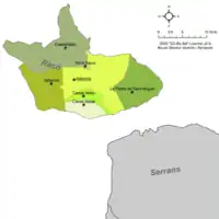
Map of municipalities of the Rincón de Ademuz
Municipalities
| Name | Population (2001)[2] |
Population (2011)[3] |
Population (2021)[4] |
|---|---|---|---|
| Ademús | 1,115 | 1,250 | 1,033 |
| Casas Altas | 161 | 155 | 130 |
| Casas Bajas | 273 | 227 | 164 |
| Castielfabib | 302 | 301 | 294 |
| La Pobla de Sant Miquel (Puebla de San Miguel) | 66 | 80 | 59 |
| Torre Baixa (Torrebaja) | 423 | 447 | 403 |
| Vallanca | 213 | 161 | 135 |
| Totals | 2,553 | 2,621 | 2,218 |
Bibliography
- Eslava Blasco, R.: Castielfabib y su patrimonio histórico-artístico. Edición del Ayuntamiento de Castielfabib. 286 Pp. ISBN 978-84-606-4689-1. Castielfabib, 2014.
- Eslava Blasco, R.: Ademuz y su patrimonio histórico-artístico. Ademuz, 2007.
- Eslava Blasco, R.: Vallanca y su patrimonio histórico-artístico religioso. Vallanca, 2006.
- Gargallo Gil, J.E.: Habla y cultura popular en el Rincón de Ademuz. Madrid, 2004.
- Rodrigo Alfonso, C.: El Rincón de Ademuz, análisis comarcal. Valencia, 1998.
- ABABOL. Revista del Instituto Cultural y de Estudios del Rincón de Ademuz (ICERA), dirigida per Ángel Antón Andrés i publicada trimestralment an Ademús des de 1995.
External links
Wikimedia Commons has media related to Rincón de Ademuz.
References
This article is issued from Wikipedia. The text is licensed under Creative Commons - Attribution - Sharealike. Additional terms may apply for the media files.