| St Andrews Victoria | |||||||||||||||
|---|---|---|---|---|---|---|---|---|---|---|---|---|---|---|---|
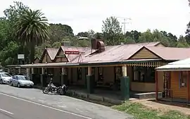
 St Andrews Hotel | |||||||||||||||
 St Andrews | |||||||||||||||
| Coordinates | 37°35′38″S 145°16′08″E / 37.594°S 145.269°E | ||||||||||||||
| Population | 1,186 (2021 census)[1] | ||||||||||||||
| Postcode(s) | 3761 | ||||||||||||||
| Elevation | 209 m (686 ft) | ||||||||||||||
| Location |
| ||||||||||||||
| LGA(s) | Shire of Nillumbik | ||||||||||||||
| State electorate(s) | Eildon | ||||||||||||||
| Federal division(s) | McEwen | ||||||||||||||
| |||||||||||||||
St Andrews is a town in Victoria, Australia, 52 km north-east of Melbourne's Central Business District, located within the Shire of Nillumbik local government area. St Andrews recorded a population of 1,186 at the 2021 census.[1]
St Andrews is well known for its alternative market, which is open every Saturday from 8am to 2pm it is closed on total fire ban days however. It also contains a hotel, primary school, bakery, CFA, general store and the Wadambuk community centre where a mobile library managed by Yarra Plenty Regional Library has a regular scheduled stop.[2]
History
Originally called Queenstown, the area was surveyed in 1858 and a town proclaimed on 25 February 1861.[3] Located between Panton Hill and Kinglake, by 1865 it was also known as St Andrews, and the presence of large numbers of Scottish miners gave rise to the town being called both ‘Caledonia’ and ‘St Andrews’.[3]
St Andrew Post Office had opened earlier on 1 January 1856 and was renamed St Andrews in 1923.[4]
It experienced population growth during the Victorian gold rush, when prospectors mined the hills around the town. St Andrews was the earliest goldfield in the area and by1855 there were 3000 miners.[3] The first discovery of gold in Queenstown was recorded in The Herald on 9 and 11 March 1855 and was attributed to a George Boston and two Scotsmen.
In April 2015, it was named Victoria's Wealthiest Town, as a result of ATO statistics. The town beat Toorak and Portsea, traditional leaders in this ranking.
St Andrews has a great community feel and is much loved by its residents and visitors alike.
Bushfires
On 7 February 2009 a major bushfire destroyed houses on Ninks, Muller, Jacksons and Wild Dog Creek Roads, as well as Buttermans Track and Olives Lane.[5] Its progression toward the town centre was halted by a southerly wind change,[5] which saved the rest of the town, but drove the fire front further east, destroying the towns of Kinglake and Marysville.
Notable residents
See also
- Shire of Eltham – St Andrews was previously within this former local government area.
References
- 1 2 Australian Bureau of Statistics (28 June 2022). "St Andrews (Vic.) (Suburbs and Localities)". 2021 Census QuickStats. Retrieved 2 July 2022.
- ↑ "Service timetable". Yarra Plenty Regional Library. 2019. Retrieved 7 February 2019.
- 1 2 3 "St Andrews | Victorian Places". www.victorianplaces.com.au. Retrieved 3 May 2019.
- ↑ Phoenix Auctions History. "Post Office List". Retrieved 12 February 2021.
- 1 2 Jackson, William (8 February 2009). "St Andrews residents devastated after fires". Whittlesea Leader. Retrieved 11 February 2009.
External links
- St Andrews Queenstown Historical Society
- Victoria's wealthiest town? St Andrews remains rich in community spirit
- St Andrews the highest earning postcode in Victoria, beating Toorak and Portsea
- St Andrews Community Market
