North Seberang Perai District | |
|---|---|
| Daerah Seberang Perai Utara | |
| Other transcription(s) | |
| • Malay | Daerah Seberang Perai Utara (Rumi) دايره سبرڠ ڤراي اوتارا (Jawi) |
| • Chinese | 威北县 (Simplified) 威北縣 (Traditional) |
| • Tamil | வட செபாராங் பிறை மாவட்டம் Vaṭa Ceparāṅ Piṟai Māvaṭṭam (Transliteration) |
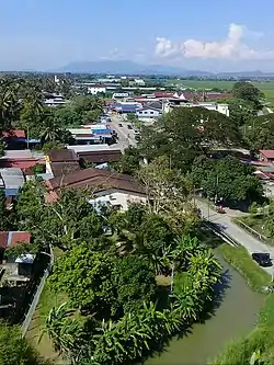 Aerial view of Kampung Maklom | |
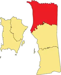 Location of North Seberang Perai District in Penang | |
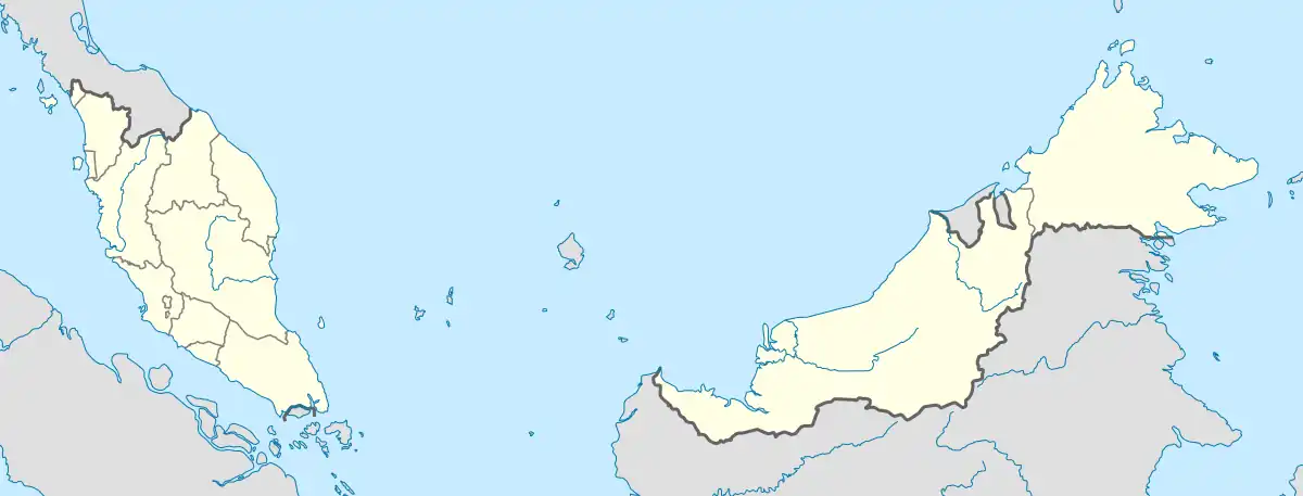 North Seberang Perai District Location of North Seberang Perai District in Malaysia | |
| Coordinates: 5°28′N 100°26′E / 5.467°N 100.433°E | |
| Country | |
| State | |
| Seat | Kepala Batas |
| Largest city | Butterworth |
| Local area government(s) | Seberang Perai City Council |
| Government | |
| • District officer | Marlia Belia[1] |
| Area | |
| • Total | 267 km2 (103 sq mi) |
| Population (2020)[3] | |
| • Total | 339,095 |
| • Density | 1,300/km2 (3,300/sq mi) |
| Time zone | UTC+8 (MST) |
| • Summer (DST) | UTC+8 (Not observed) |
| Postcode | 12000-13800 |
| Calling code | +6-043 |
| Vehicle registration plates | P |
The North Seberang Perai District (Malay: Daerah Seberang Perai Utara; abbreviated: "SPU") is an administrative district on the mainland part of Penang State, Malaysia. It covers an area of 267 square kilometres, and had a population of 286,323 at the 2010 Census.[3] The district is bordered by Muda River in the north which separates Kuala Muda district in Kedah, Kedah state border in the east which separates Kulim district, Perai River in the south which separates Central Seberang Perai and North Channel which separates Penang Island. The district capital is Kepala Batas, and the largest town is Butterworth. Other localities that are located in North Seberang Perai include Penaga, Pinang Tunggal, Bertam, Tasek Gelugor, Teluk Air Tawar and Mak Mandin. It is one of the three administrative districts in the Seberang Perai region, the mainland portion of Penang State. Paddy is largely cultivated in North Seberang Perai as most parts of it is covered by paddy fields.[4]
Administrative divisions

SPU District is divided into 15 mukims and also consist of 2 towns which are Butterworth and Kepala Batas.[5][6]
Demographics
| Year | Pop. | ±% |
|---|---|---|
| 1991 | 224,647 | — |
| 2000 | 243,938 | +8.6% |
| 2010 | 288,692 | +18.3% |
| 2020 | 339,095 | +17.5% |
| Source: [7] | ||
The following is based on Department of Statistics Malaysia 2020 census.[3]
| Ethnic groups in North Seberang Perai, 2020 census | ||
|---|---|---|
| Ethnicity | Population | Percentage |
| Bumiputera | 203,698 | 60.07% |
| Chinese | 95,554 | 28.18% |
| Indian | 22,597 | 6.66% |
| Others | 968 | 0.29% |
| Non-Malaysian citizens | 16,278 | 4.80% |
| Total | 339,095 | 100% |
Federal Parliament and State Assembly Seats
List of North Seberang Perai district representatives in the Federal Parliament (Dewan Rakyat)
| Parliament | Seat Name | Member of Parliament | Party |
|---|---|---|---|
| P41 | Kepala Batas | Siti Mastura Muhammad | Perikatan Nasional (PAS) |
| P42 | Tasek Gelugor | Wan Saiful Wan Jan | Perikatan Nasional (PPBM) |
| P43 | Bagan | Lim Guan Eng | Pakatan Harapan (DAP) |
List of North Seberang Perai district representatives in the State Legislative Assembly of Penang
| Parliament | State | Seat Name | State Assemblyman | Party |
|---|---|---|---|---|
| P41 | N1 | Penaga | Mohd Yusni bin Mat Piah | Perikatan Nasional (PAS) |
| P41 | N2 | Bertam | Reezal Merican Naina Merican | Barisan Nasional (UMNO) |
| P41 | N3 | Pinang Tunggal | Bukhori Ghazali | Perikatan Nasional (PAS) |
| P42 | N4 | Permatang Berangan | Mohd Sobri Salleh | Perikatan Nasional (PAS) |
| P42 | N5 | Sungai Dua | Muhammad Fauzi Yusoff | Perikatan Nasional (PAS) |
| P42 | N6 | Telok Air Tawar | Azmi Alang | Perikatan Nasional (BERSATU) |
| P43 | N7 | Sungai Puyu | Phee Syn Tze | Pakatan Harapan (DAP) |
| P43 | N8 | Bagan Jermal | Chee Yeeh Keen | Pakatan Harapan (DAP) |
| P43 | N9 | Bagan Dalam | Kumaran A/L Krishnan | Pakatan Harapan (DAP) |
See also
References
- ↑ Webmaster, SPU. "Senarai Pegawai Daerah PDTSPU". spu.penang.gov.my.
- ↑ "2017 Q2 statistics" (PDF). Penang Institute. Archived from the original (PDF) on 2017-12-01. Retrieved 2017-11-30.
- 1 2 3 "Population Distribution and Basic Demographic Characteristics, 2010" (PDF). Department of Statistics, Malaysia. Archived from the original (PDF) on 22 May 2014. Retrieved 19 April 2012.
- ↑ "Latarbelakang".
- ↑ "Pengenalan". spu.penang.gov.my.
- ↑ "UPI – Unique Parcel Identifier". myliis3.mygeoportal.gov.my. Archived from the original on 2017-12-27. Retrieved 2017-11-30.
- ↑ "Key Findings of Population and Housing Census of Malaysia 2020" (pdf) (in Malay and English). Department of Statistics, Malaysia. ISBN 978-967-2000-85-3.
Capital: George Town | |||||||||||||||||||||||||||||||
| Topics | |||||||||||||||||||||||||||||||
| Society | |||||||||||||||||||||||||||||||
| Administrative divisions |
| ||||||||||||||||||||||||||||||
| |||||||||||||||||||||||||||||||