Sibolga | |
|---|---|
| City of Sibolga Kota Sibolga | |
| Other transcription(s) | |
| • Batak | ᯘᯪᯅᯬᯞ᯲ᯎ |
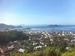 Sibolga view from Simarbarimbing hill, 2016 | |
 Seal | |
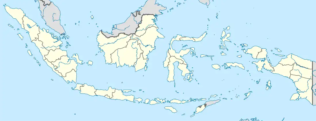
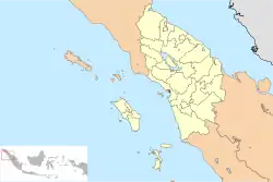 Location within North Sumatra | |
| Coordinates: 1°44′24″N 98°46′48″E / 1.74000°N 98.78000°E | |
| Country | |
| Province | |
| Government | |
| • Mayor | Syarfi Hutauruk |
| • Vice Mayor | Edi Polo Sitanggang |
| • Chairman of City's Council of Representatives | Akhmad Syukri Nazry Penarik (Nasdem) |
| • Vice Chairman of City's Council of Representatives | Jamil Zeb Tumori (Golkar) |
| Area | |
| • Total | 10.77 km2 (4.16 sq mi) |
| Population (mid 2022 estimate) | |
| • Total | 90,366 |
| • Density | 8,400/km2 (22,000/sq mi) |
| [1] | |
| Time zone | UTC+7 (Indonesia Western Time) |
| Area code | (+62) 631 |
| Website | www |
Sibolga (formerly sometimes Siboga) is a city and a port located in the natural harbour of Sibolga Bay on the west coast of North Sumatra province, in Indonesia.
The city is located on the western side of North Sumatra facing the Indian Ocean, is a transit harbour to Nias Island, and was hard hit during the 2004 Indian Ocean earthquake. Sibolga is also a semi-enclave within Central Tapanuli Regency, as Sibolga borders Central Tapanuli Regency in the north, east, and south, while it borders with the Mentawai Strait in the west.
The city has an area of 10.77 km2 and is the smallest city by land area in Indonesia.[2] It had a population of 84,444 at the 2010 census[3] and 89,584 at the 2020 census;[4] the official estimate as at mid 2022 was 90,366.[1]
Administrative districts
The city is divided into four districts (kecamatan), tabulated below with their areas and their populations at the 2010 census[3] and the 2020 census,[4] together with the official estimates as at mid 2022.[1] The table also includes the number of administrative villages (all classed as urban kelurahan) in each district and its post codes.
| Kode Wilayah | Name of District (kecamatan) | Area in km2 | Pop'n census 2010 | Pop'n census 2020 | Pop'n estimate mid 2022 | No. of villages | Post codes |
|---|---|---|---|---|---|---|---|
| 12.73.01 | Sibolga Utara (North Sibolga) | 3.33 | 19,970 | 21,383 | 21,547 | 5 | 22511 -22514 |
| 12.73.02 | Sibolga Kota (Sibolga Town) | 2.73 | 14,304 | 15,172 | 15,260 | 4 | 22521 -22524 |
| 12.73.03 | Sibolga Selatan (South Sibolga) | 3.14 | 30,082 | 33,346 | 33,827 | 4 | 22533 -22538 |
| 12.73.04 | Sibolga Sambas | 1.57 | 20,125 | 19,683 | 19,732 | 4 | 22531 -22535 |
| Totals | 10.77 | 84,441 | 89,584 | 90,366 | 17 |
History
Poncan Ketek Island (Small Poncan Island) in Sibolga Bay was once the location of a fort, with British, Dutch, French and American traders passed through. It is thought Stamford Raffles passed through before he moved to Bengkulu in southern Sumatra. From Bengkulu Raffles, after relinquishing the port to the Dutch, established the trade port that became Singapore.
At some point between 1890 and 1920 there was a major fire in the city, which was presumably mostly built from wood from the surrounding mountains (shown partly denuded in the 1928 panorama below).
After the Japanese invasion of Sumatra in 1942, a makeshift prison described as a "civilian camp" was set up at Taroetoengweg, in the city center, from 16 March to 4 May 1942. It first housed 10 "European" men from in and around Sibolga, who were then joined on April 24 by another 10 men from the island of Nias. On May 4 they were taken to the Native Secondary School for Boys in Pearadja (Taroetoeng), located in the mountains behind Sibolga.[5]
Transport and tourism
Buses are available from Medan, Parapat and Padang. Ferries from here service the outlying islands to the west, Simeulue and Nias, as well as the rest of Indonesia. Sibolga is a step off point for trade and passenger boats to Nias Island. The local airport is Ferdinand Lumban Tobing Airport.
Climate
This area has a tropical rainforest climate with no real dry season. Regions with this climate typically feature tropical rainforests, and are designated by the Köppen climate classification as "Af".[6]
| Climate data for Sibolga | |||||||||||||
|---|---|---|---|---|---|---|---|---|---|---|---|---|---|
| Month | Jan | Feb | Mar | Apr | May | Jun | Jul | Aug | Sep | Oct | Nov | Dec | Year |
| Mean daily maximum °C (°F) | 31 (87) |
31 (88) |
31 (88) |
31 (87) |
31 (88) |
31 (88) |
31 (87) |
30 (86) |
29 (85) |
30 (86) |
30 (86) |
31 (87) |
31 (87) |
| Mean daily minimum °C (°F) | 23 (74) |
23 (74) |
23 (74) |
24 (75) |
24 (75) |
23 (74) |
23 (73) |
23 (73) |
23 (73) |
23 (73) |
23 (74) |
23 (73) |
23 (74) |
| Average precipitation mm (inches) | 300 (11.8) |
280 (11.0) |
390 (15.4) |
420 (16.5) |
310 (12.2) |
230 (9.1) |
280 (11.0) |
350 (13.8) |
370 (14.6) |
490 (19.3) |
450 (17.7) |
420 (16.5) |
4,290 (168.9) |
| Source: Weatherbase [7] | |||||||||||||
Gallery
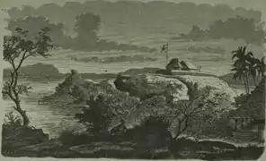 Fort Tapanuli on Poncan Ketek Island in 1878
 Devastation after the fire (ca. 1890–1920)
 Devastation after the fire (ca. 1890–1920)
 Devastation after the fire (ca. 1890–1920)
 Entrance gate to Sibolga's Chinese Quarter, 1920
 Government bus descending Sibolga's mountain road, June 1919
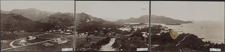 Panorama of Sibolga, 1928
References
- 1 2 3 Badan Pusat Statistik, Jakarta, 2023, Kota Sibolga Dalam Angka 2023 (Katalog-BPS 1102001.1273)
- ↑ "5 Kota Terkecil di Indonesia, yang Paling Kecil Luasnya Hanya 10 KM Persegi!". VOI - Waktunya Merevolusi Pemberitaan (in Indonesian). Retrieved 19 November 2022.
- 1 2 Biro Pusat Statistik, Jakarta, 2011.
- 1 2 Badan Pusat Statistik, Jakarta, 2021.
- ↑ "Search in this website - East Indies camp archives".
- ↑ "Sibolga, Indonesia Köppen Climate Classification (Weatherbase)". Weatherbase.
- ↑ "Weatherbase.com". Weatherbase. 2013. Retrieved on October 5, 2013.
External links
![]() Media related to Sibolga at Wikimedia Commons
Media related to Sibolga at Wikimedia Commons
