
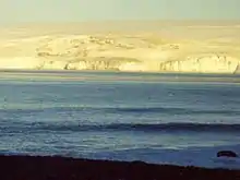

Smolyan Point (Nos Smolyan \'nos 'smo-lyan\) is located on the north-western coast of South Bay, Livingston Island in the South Shetland Islands, Antarctica forming the northwest side of the entrance to Emona Anchorage. The ice-covered point shows conspicuous radial crevasses spreading inland and ends up with a 25 m wide and 4 m high rock. The feature was formed as a result of Pimpirev Glacier's retreat in the late 20th century.
Smolyan is the name of a town in the Rhodope Mountains in southern Bulgaria.
Location
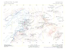
The point is located at 62°37′27.7″S 60°25′57″W / 62.624361°S 60.43250°W, which is 1.86 km east-northeast of Ereby Point and 3.7 km northwest of Hespérides Point. (Bulgarian mapping in 1996, 2005 and 2009 from a 1995/96 Bulgarian topographic survey).
Maps
- L.L. Ivanov. Livingston Island: Central-Eastern Region. Scale 1:25000 topographic map. Sofia: Antarctic Place-names Commission of Bulgaria, 1996.
- L.L. Ivanov et al. Antarctica: Livingston Island and Greenwich Island, South Shetland Islands. Scale 1:100000 topographic map. Sofia: Antarctic Place-names Commission of Bulgaria, 2005.
- L.L. Ivanov. Antarctica: Livingston Island and Greenwich, Robert, Snow and Smith Islands. Scale 1:120000 topographic map. Troyan: Manfred Wörner Foundation, 2009. ISBN 978-954-92032-6-4
References
- Smolyan Point. SCAR Composite Antarctic Gazetteer
- Bulgarian Antarctic Gazetteer. Antarctic Place-names Commission. (details in Bulgarian, basic data in English)
External links
- Smolyan Point. Copernix satellite image
This article includes information from the Antarctic Place-names Commission of Bulgaria which is used with permission.