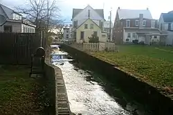
Stevens Run[1] (Stevens Creek,[2] Tiber) is a 2.2-mile-long (3.5 km)[3] tributary of Rock Creek in Pennsylvania in the United States.
Stevens Run flows over the Gettysburg Battlefield and through the borough of Gettysburg, Pennsylvania. Within the borough the stream is in a concrete channel, including a covered portion. From 1884 to 1942, the run was spanned by three bridges of the Round Top Branch railroad.[4]
History
Stevens Run was named after Thaddeus Stevens, a congressman from Pennsylvania.[5]
Samuel Gettys' Tavern was located on the south side on the uphill slope of the now-named Stevens Run, and Rock Creek Church was approximately on the north bank of the now-named Carlisle Street and Stevens Run.[6] In 1902, a new bridge was built over the Tiber on Chambersburg Street.
| Course, northeast-to-southwest | |||||
| Intersection | Location/Description | Coordinates | |||
|---|---|---|---|---|---|
| Mouth | Rock Creek confluence | ||||
| Bridge | site of 1912 bridge | ||||
| Bridge | Former borough site of 1920 bridge | ||||
| Boundary | Exits GNMP land | ||||
| Run | Confluence with flow from Colt Park | 39°49.319′N 77°14.529′W / 39.821983°N 77.242150°W | |||
| Perennial flow[7] | 39°48′59″N 77°15′19″W / 39.81631°N 77.25540°W | ||||
| Flow from Plum & Guinn runs' triple pt | |||||
| Headpoint | N of Codori house & barn[7] | 39°48′42″N 77°14′25″W / 39.81178°N 77.24021°W | |||
See also
References
- ↑ "Stevens Run (1188630)". Geographic Names Information System. United States Geological Survey, United States Department of the Interior.
- ↑ Balch, William Ralston; Butler, John M. (1885). The Battle of Gettysburg: An Historical Account (Google Books). Harrisburg, Pennsylvania: Lane S. Hart. Retrieved 2011-06-09.
- ↑ U.S. Geological Survey. National Hydrography Dataset high-resolution flowline data. The National Map Archived 2012-03-29 at the Wayback Machine, accessed August 15, 2011
- ↑ Map of the Battle Field of Gettysburg (Map). Cartography by Gettysburg National Park Commission: Nicholson, John P; Cope, Emmor; Hammond, Schuyler A. New York: Julius Bien & Co. Lith. 1904. Retrieved 2011-06-07.
{{cite map}}: External link in|cartography= - ↑ "Stevens Run is historic". Gettysburg Times. Jan 5, 1999. p. 3. Retrieved 24 December 2015.
- ↑ "[Alexander Dobbin article]". The Gettysburg Experience. Archived from the original on 2010-11-28. Retrieved 2011-12-04.
Rock Creek Church…located one mile north of the future town of Gettysburg (located near the junction of Carlisle Street and the Mummasburg Road)
- 1 2 "The National Map". National Hydrography Dataset. NationalMap.gov (USGS). Archived from the original (NHD Viewer) on 2012-03-23. Retrieved 2011-07-21.