| Huacshash | |
|---|---|
| Huaqshash | |
 | |
| Highest point | |
| Elevation | 5,644 m (18,517 ft) |
| Listing | List of mountains in Peru |
| Coordinates | 10°24′50″S 76°58′30″W / 10.41389°S 76.97500°W |
| Naming | |
| Language of name | Quechua |
| Geography | |
 Huacshash Peru | |
| Location | Peru, Lima Region |
| Parent range | Andes, Huayhuash |
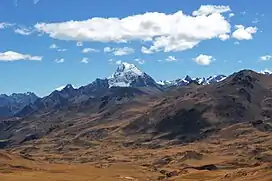
Huacshash[1][2] or Huaqshash[3] (possibly from local Quechua waqsa, meaning eye tooth)[4] is a mountain in the west of the Huayhuash mountain range in the Andes of Peru, about 5,644 metres (18,517 ft) high.[1][2] It is located in the Lima Region, Cajatambo Province, Cajatambo District.[5] Huacshash lies on a sub-range in the west, south of the Huayllapa River, north of the Pumarinri River and southeast of the villages of Huayllapa and Auquimarca.[2][3]
References
- 1 2 Neate, Jill (1994). "Peru". Mountaineering in the Andes (PDF). RGS-IBG Expedition Advisory Centre. p. 25. ISBN 0-907649-64-5.
- 1 2 3 Peru 1:100 000, Yanahuanca (21-j). IGN (Instituto Geográfico Nacional - Perú).
Huacshah
- 1 2 Díaz, Felipe (2008–2009). Carta Turística. Cordilleras Blanca, Negra, Huayhuash y Callejón de Huaylas.
- ↑ Teofilo Laime Ajacopa (2007). Diccionario Bilingüe: Iskay simipi yuyayk’anch: Quechua – Castellano / Castellano – Quechua (PDF). La Paz, Bolivia: futatraw.ourproject.org.
- ↑ escale.minedu.gob.pe UGEL map of the Cajatambo Province (Lima Region)]
This article is issued from Wikipedia. The text is licensed under Creative Commons - Attribution - Sharealike. Additional terms may apply for the media files.