West New Britain Province
| |
|---|---|
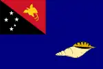
 Flag | |
 West New Britain Province in Papua New Guinea | |
| Coordinates: 5°50′S 150°0′E / 5.833°S 150.000°E | |
| Country | Papua New Guinea |
| Formation | 1976 |
| Capital | Kimbe |
| Districts | |
| Government | |
| • Governor | Sasindran Muthuvel 2012- |
| Area | |
| • Total | 20,387 km2 (7,871 sq mi) |
| Population (2011 census) | |
| • Total | 264,264 |
| • Density | 13/km2 (34/sq mi) |
| Time zone | UTC+10 (AEST) |
| HDI (2019) | 0.592[1] medium · 6th of 22 |
West New Britain is a province of Papua New Guinea on the islands of New Britain. The provincial capital is Kimbe. The area of the province is 20,387 km² with a population of 264,264 as of the 2011 census.[2] The province's only land border is with East New Britain. There are seven major tribes, the Nakanai, Bakovi, Kove, Unea, Maleu, Arowe, speaking about 25 languages.
People from West New Britain are referred to as "Kombes" in Papua New Guinea, in metonymic reference to the significant Kove (or Kombe) people. The Kove people were reported on by the anthropologist Ann Chowning in National Geographic magazine during the 1960s. Within Papua New Guinea they are noted for their practice of superincision of the penis — circumcision is generally though inaccurately referred to among Papua New Guineans as "the Kombe cut" — but was formerly practiced in other northern coastal regions of New Guinea island and the New Guinea Islands.
The predominant religious affiliation is Roman Catholic, though there is a sizeable Anglican presence at the extreme western tip of the province and Bishop James Ayong, the retired Anglican prelate of Papua New Guinea, is originally from West New Britain.
West New Britain produces palm oil for export with large oil palm plantations on the north coast of the province especially in the Kimbe region. There are logging activities in the interior and on the south coast. The Walindi dive resort near Kimbe is a tourist destination for visitors to Papua New Guinea.
Districts and LLGs
There are two districts in the province. Each district has one or more Local Level Government (LLG) areas. For census purposes, the LLG areas are subdivided into wards and those into census units.[3]
Provincial leaders
The province was governed by a decentralised provincial administration, headed by a Premier, from 1978 to 1995. Following reforms taking effect that year, the national government reassumed some powers, and the role of Premier was replaced by a position of Governor, to be held by the winner of the province-wide seat in the National Parliament of Papua New Guinea.[4][5]
Premiers (1978–1995)
| Premier | Term |
|---|---|
| Bernard Vogae | 1978–1987 |
| Joseph Lehen | 1987–1988 |
| Robert Lawrence | 1988–1993 |
| Bernard Vogae | 1993–1995 |
Governors (1995–present)
| Governor | Term |
|---|---|
| Lucas Waka | 1995–1997 |
| Bernard Vogae | 1997–2000 |
| Clement Nakmai | 2000–2007 |
| Peter Humphreys | 2007–2012 |
| Sasindran Muthuvel | 2012–present |
Members of the National Parliament
The province and each district is represented by a Member of the National Parliament. There is one provincial electorate and each district is an open electorate.
| Electorate | Member |
|---|---|
| West New Britain Provincial | Sasindran Muthuvel |
| Nakanai Open | Francis Maneke |
| Kandrian-Gloucester Open | Joseph Lelang |
| Talasea Open | Freddy R Kumai |
References
- ↑ "Sub-national HDI - Area Database - Global Data Lab". hdi.globaldatalab.org. Retrieved 2020-04-18.
- ↑ "Papua New Guinea". City Population.de. Thomas Brinkhoff. Retrieved 26 June 2012.
- ↑ "National Statistical Office of Papua New Guinea". National Statistical Office of Papua New Guinea. National Statistical Office of Papua New Guinea. Retrieved 26 June 2012.
- ↑ May, R. J. "8. Decentralisation: Two Steps Forward, One Step Back". State and society in Papua New Guinea: the first twenty-five years. Australian National University. Retrieved 31 March 2017.
- ↑ "Provinces". rulers.org. Retrieved 31 March 2017.