Škrjančevo | |
|---|---|
 | |
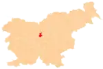
 Škrjančevo Location in Slovenia | |
| Coordinates: 46°10′4.93″N 14°36′28.81″E / 46.1680361°N 14.6080028°E | |
| Country | |
| Traditional region | Upper Carniola |
| Statistical region | Central Slovenia |
| Municipality | Domžale |
| Area | |
| • Total | 0.51 km2 (0.20 sq mi) |
| Elevation | 323.4 m (1,061.0 ft) |
| Population (2020) | |
| • Total | 349 |
| • Density | 680/km2 (1,800/sq mi) |
| [1] | |
Škrjančevo (pronounced [ʃkəˈɾjaːntʃɛʋɔ]) is a settlement on the left bank of the Kamnik Bistrica River south of Radomlje in the Municipality of Domžale in the Upper Carniola region of Slovenia.[2]
References
External links
 Media related to Škrjančevo at Wikimedia Commons
- Škrjančevo on Geopedia
| Settlements | Administrative seat: Domžale
|  |
|---|---|---|
| Infrastructure | ||
| Landmarks |
| |
| Notable people | ||
This article is issued from Wikipedia. The text is licensed under Creative Commons - Attribution - Sharealike. Additional terms may apply for the media files.