Žákava | |
|---|---|
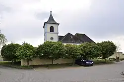 Church of Saint Lawrence | |
 Flag  Coat of arms | |
 Žákava Location in the Czech Republic | |
| Coordinates: 49°37′48″N 13°31′51″E / 49.63000°N 13.53083°E | |
| Country | |
| Region | Plzeň |
| District | Plzeň-South |
| First mentioned | 1350 |
| Area | |
| • Total | 9.47 km2 (3.66 sq mi) |
| Elevation | 362 m (1,188 ft) |
| Population (2023-01-01)[1] | |
| • Total | 479 |
| • Density | 51/km2 (130/sq mi) |
| Time zone | UTC+1 (CET) |
| • Summer (DST) | UTC+2 (CEST) |
| Postal code | 332 04 |
| Website | www |
Žákava is a municipality and village in Plzeň-South District in the Plzeň Region of the Czech Republic. It has about 500 inhabitants.
Žákava lies approximately 18 kilometres (11 mi) south-east of Plzeň and 82 km (51 mi) south-west of Prague.
References
Wikimedia Commons has media related to Žákava.
This article is issued from Wikipedia. The text is licensed under Creative Commons - Attribution - Sharealike. Additional terms may apply for the media files.