Ambatondrazaka District | |
|---|---|
 Ambatondrazaka | |
 Ambatondrazaka District Location in Madagascar | |
| Coordinates: 17°50′0″S 48°25′0″E / 17.83333°S 48.41667°E | |
| Country | |
| Region | Alaotra-Mangoro |
| District | Ambatondrazaka |
| Area | |
| • Total | 6,967 km2 (2,690 sq mi) |
| Population (2013) | |
| • Total | 324,610 |
| • Density | 47/km2 (120/sq mi) |
| Climate | Cwa |
Ambatondrazaka District is a district in the Alaotra-Mangoro Region of Madagascar. Its capital is the town of Ambatondrazaka. The district has an area of 6,967 km2 (2,690 sq mi), and the estimated population in 2013 was 324,610.[1]
Geography
The city is situated south of Alaotra, the greatest lake in Madagascar.
Religion
- FJKM - Fiangonan'i Jesoa Kristy eto Madagasikara (Church of Jesus Christ in Madagascar)
- FLM - Fiangonana Loterana Malagasy (Malagasy Lutheran Church)
- Roman Catholic Diocese of Ambatondrazaka (Cathedral of the Holy Trinity).
Transport
The district is linked to Moramanga by the MLA (Moramanga–Lac Alaotra) railway and the Route nationale 44 (Moramanga–Ambatondrazaka–Imerimandroso–Amboavory). There is also an airport in Ambatondrazaka.
Communes
The district is further divided into 20 communes:
References
Capital: Ambatondrazaka | ||
| Ambatondrazaka (21) | 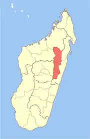 | |
| Amparafaravola (21) | ||
| Andilamena (8) | ||
| Anosibe An'ala (11) | ||
| Moramanga (22) | ||
5 districts; 82 communes | ||
This article is issued from Wikipedia. The text is licensed under Creative Commons - Attribution - Sharealike. Additional terms may apply for the media files.