Amporoforo | |
|---|---|
 Amporoforo Location in Madagascar | |
| Coordinates: 17°50′10″S 49°08′15″E / 17.83611°S 49.13750°E | |
| Country | |
| Region | Atsinanana |
| District | Toamasina II |
| Elevation | 229 m (751 ft) |
| Population (2019)Census | |
| • Total | 5,769 |
| Time zone | UTC3 (EAT) |
| Postal code | 501 |
Amporoforo is a rural commune in the district of Toamasina II (district), in the region of Atsinanana, on the east coast of Madagascar. It is situated 50 km north-west of Toamasina.
Economy
The economy is based on agriculture. Rice, manioc & corn are grown, other crops are lychee, cloves, cacao, coffee, papaya, banana and sugar cane.
References
- ↑ "Amporoforo (Madagascar) map". nona.net. Retrieved 2021-09-09.
Capital: Toamasina | ||
| Antanambao Manampotsy - 507 | 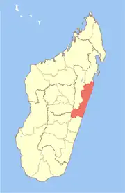 | |
| Mahanoro - 510 | ||
| Marolambo - 513 | ||
| Toamasina I - 501 | ||
| Toamasina II - 502 | ||
| Vatomandry - 517 | ||
| Vohabinany (Brickaville) - 508 | ||
7 districts; 75 communes | ||
This article is issued from Wikipedia. The text is licensed under Creative Commons - Attribution - Sharealike. Additional terms may apply for the media files.