| Antelope Ridge | |
|---|---|
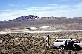 View northeast from the Drum Mountains, showing a sequence of rhyolite flows, vitrophyre, and tuff of Topaz Mountain Rhyolite on Antelope Ridge (USGS photo) | |
| Highest point | |
| Elevation | 5,417 ft (1,651 m) |
| Geography | |
| Country | United States |
| Region | Utah |
| District | Great Basin |
| Range coordinates | 39°42′30″N 113°03′13″W / 39.7083°N 113.0536°W |
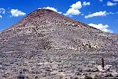
Crossbedded tuff of Topaz Mountain Rhyolite at the south end of Antelope Ridge (USGS photo)
Antelope Ridge is a group of hills in Juab County, Utah.[1] It is located east of Topaz Mountain.
References
- ↑ Topaz Mountain East, UT. USGS 7.5' Quadrangle. 2020.
This article is issued from Wikipedia. The text is licensed under Creative Commons - Attribution - Sharealike. Additional terms may apply for the media files.