Arkana, Arkansas | |
|---|---|
 Arkana, Arkansas Arkana's position in Arkansas.  Arkana, Arkansas Arkana, Arkansas (the United States) | |
| Coordinates: 36°14′18″N 92°19′00″W / 36.23833°N 92.31667°W | |
| Country | |
| State | |
| County | Baxter |
| Township | Buckhorn |
| Elevation | 226 m (741 ft) |
| Time zone | UTC-6 (Central (CST)) |
| • Summer (DST) | UTC-5 (CDT) |
| GNIS feature ID | 70461 |
| U.S. Geological Survey Geographic Names Information System: Arkana, Baxter County, Arkansas | |
Arkana is an unincorporated community in Baxter County, Arkansas, United States.[1] The community is located along Arkansas Highway 201.[2]
The rural crossroads was initially known as Gobbler's Flat from an abundance of wild turkey. It was home to a large general store and post office that served the local population. The Arkana school once had the largest enrollment in Baxter County.[3]
References
- ↑ "Feature Detail Report for: Arkana, Arkansas." USGS. U.S. Geological Survey Geographic Names Information System: Arkana, Baxter County, Arkansas Retrieved March 14, 2011.
- ↑ Arkansas Atlas and Gazetteer (Map) (Second ed.). DeLorme. § 25.
- ↑ Messick, Mary Ann (1973). History of Baxter County (Centennial ed.). Mountain Home, Arkansas: Mountain Home Chamber of Commerce. pp. 80–82. LCCN 73-82235. OCLC 724611.
Municipalities and communities of Baxter County, Arkansas, United States | ||
|---|---|---|
| Cities | 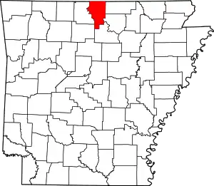 Map of Arkansas highlighting Baxter County | |
| Towns | ||
| CDPs | ||
| Other unincorporated communities | ||
| Footnotes | ‡This populated place also has portions in an adjacent county or counties | |
This article is issued from Wikipedia. The text is licensed under Creative Commons - Attribution - Sharealike. Additional terms may apply for the media files.