 View of Aukena from Mangareva | |
 Aukena | |
| Geography | |
|---|---|
| Location | Pacific Ocean |
| Coordinates | 23°06′42″S 134°54′01″W / 23.11167°S 134.90028°W |
| Archipelago | Tuamotus |
| Area | 1.35 km2 (0.52 sq mi) |
| Length | 2.5 km (1.55 mi) |
| Width | 0.5 km (0.31 mi) |
| Highest elevation | 198 m (650 ft) |
| Highest point | (unnamed) |
| Administration | |
France | |
| Overseas collectivity | French Polynesia |
| Administrative subdivision | Tuamotus |
| Commune | Gambier Islands |
| Demographics | |
| Population | 40[1] (2012) |
| Pop. density | 30/km2 (80/sq mi) |
Aukena is the 5th largest of the Gambier Islands in French Polynesia. Aukena is located about halfway between Mangareva and Akamaru, or about 5 km southeast of Mangareva, which is the largest island of the whole Gambier Islands archipelago. Aukena is approximately 2.5 km long and about 0.5 km wide, with a total area of 1.35 km2.
Mangarevan oral tradition first mentions the island in the fourteenth century, and archeological excavations show that it has been inhabited since that time.[2]
Gallery
 Watchtower. Background: Mangareva Island
 Watchtower. Background: Mt. Duff
 Ruins of Re'e Seminary College, the first college of French Polynesia
 Church of St.Raphael
 Oven for coral lime. Missionaries used it to build various churches in the Gambier Islands.
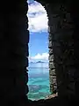 View from the watchtower. View is of Manui and Kamaka
References
- ↑ "Population". Institut de la statistique de la Polynésie française. Archived from the original on 11 April 2020. Retrieved 25 September 2014.
- ↑ Green, Roger C.; Weisler, Marshall I. (2002). "The Mangarevan Sequence and Dating of the Geographic Expansion into Southeast Polynesia". Asian Perspectives. 41 (2): 225–229. Retrieved 20 December 2022.
Wikimedia Commons has media related to Aukena.
Tuamotus Gambiers | Islands/Atolls | ||
|---|---|---|---|
| Island groups | |||
This article is issued from Wikipedia. The text is licensed under Creative Commons - Attribution - Sharealike. Additional terms may apply for the media files.