Aydelotte | |
|---|---|
 Aydelotte Location within the state of Oklahoma  Aydelotte Aydelotte (the United States) | |
| Coordinates: 35°26′39″N 96°54′42″W / 35.44417°N 96.91167°W | |
| Country | United States |
| State | Oklahoma |
| County | Pottawatomie |
| Elevation | 991 ft (302 m) |
| Time zone | UTC-6 (Central (CST)) |
| • Summer (DST) | UTC-5 (CDT) |
| GNIS feature ID | 1089773[1] |
Aydelotte is a community located in Pottawatomie County, Oklahoma, United States. It is north of Shawnee and just south of Meeker along Oklahoma State Highway 18.[2] The town as platted by the Santa Fe Railroad in 1903 was called Hansmeyer, but became Aydelotte for one of the railroad employees, J.M. Aydelotte.
References
- 1 2 U.S. Geological Survey Geographic Names Information System: Aydelotte, Oklahoma
- ↑ "Aydelotte, OK". Google Maps. Retrieved October 13, 2023.
Shirk, George H. Oklahoma Place Names. Norman: University of Oklahoma Press, 1987. ISBN 0-8061-2028-2 .
Municipalities and communities of Pottawatomie County, Oklahoma, United States | ||
|---|---|---|
| Cities | 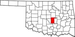 Pottawatomie County map | |
| Towns | ||
| CDP | ||
| Other communities | ||
| Ghost towns | ||
| Footnotes | ‡This populated place also has portions in an adjacent county or counties | |
This article is issued from Wikipedia. The text is licensed under Creative Commons - Attribution - Sharealike. Additional terms may apply for the media files.