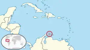
Location of Aruba
There are more than a dozen beaches of Aruba. Aruba is part of the Kingdom of the Netherlands and an island country in the mid-south of the Caribbean Sea.
Beaches
The beaches of Aruba include the following:
- Andicuri Beach, 12°32′25″N 69°57′15″W / 12.54017°N 69.95405°W[1]
- Arashi Beach, 12°36′34″N 70°03′14″W / 12.60955°N 70.05398°W[2][1]
- Baby Beach, 12°24′53″N 69°52′51″W / 12.414691561947045°N 69.88080110113886°W[1][3]
- Bachelor's Beach, 12°25′55″N 69°52′19″W / 12.432048879438073°N 69.87190087340504°W[3]
- Beach at the Blue Residences, 12°33′42″N 70°03′17″W / 12.561552177770563°N 70.05461831601973°W[3]
- Boca Catalina Beach, 12°36′17″N 70°03′06″W / 12.604599275220952°N 70.05154788992112°W[1][3]
- Boca Grandi Beach, 12°26′25″N 69°52′26″W / 12.440179110955492°N 69.87391789463777°W[3]
- Boca Prins Beach, Arikok National Park, 12°29′57″N 69°54′25″W / 12.499268155134015°N 69.90690549769073°W[1][3]
- Cura Cabay Beach, 12°26′25″N 69°55′49″W / 12.440230544063645°N 69.93035316884772°W
- Daimari Beach, 12°31′52″N 69°56′25″W / 12.53097730179607°N 69.9402757457267°W[3]
- Divi Beach, 12°32′15″N 70°03′34″W / 12.537543549026955°N 70.05944983277939°W[3]
- Dos Playa Beach, Arikok National Park, 12°30′21″N 69°55′08″W / 12.505709317860248°N 69.91879125150759°W[1]
- Druif Beach, 12°36′20″N 70°01′54″W / 12.60569°N 70.0318°W[1][4]
- Eagle Beach, 12°32′52″N 70°03′25″W / 12.54786°N 70.0569°W[5][1]
- Flamingo Beach, Renaissance Island, 12°30′05″N 70°01′46″W / 12.50127°N 70.02953°W[6]
- Grapefield Beach, 12°26′55″N 69°52′37″W / 12.448602432969578°N 69.8770077994854°W
- Hadicurari Beach, 12°35′09″N 70°02′46″W / 12.585830474743323°N 70.04606410264978°W[1][3]
- Iguana Beach, 12°30′01″N 70°01′42″W / 12.50036°N 70.02834°W[7]
- Malmok Beach, 12°35′53″N 70°02′59″W / 12.598006661360682°N 70.04978184187625°W[1][3]
- Manchebo Beach, 12°32′25″N 70°03′48″W / 12.54024°N 70.06342°W[8]
- Mangel Halto Beach, 12°27′54″N 69°58′10″W / 12.464923508766375°N 69.96952414935305°W[3]
- Palm Beach, 12°34′31″N 70°02′45″W / 12.575175775385796°N 70.04573530313544°W[9][1][3]
- De Palm Island, 12°28′20″N 69°59′10″W / 12.472150386817194°N 69.98618229648267°W[1][3]
- Rincon Beach, 12°27′17″N 69°52′47″W / 12.454731170852979°N 69.87963636429994°W[3]
- Rodgers Beach, 12°25′02″N 69°53′03″W / 12.41719°N 69.88413°W[10][1]
- Surfside Beach, 12°30′23″N 70°01′49″W / 12.5063215093638°N 70.03022095363487°W[1][3]
- Wariruri Beach, 12°33′33″N 69°59′17″W / 12.559253559320023°N 69.98819072756311°W[3]
Gallery
Beach scenes in Aruba
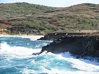 Andicuri beach from natural bridge
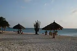 Arashi Beach
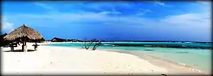 Baby Beach
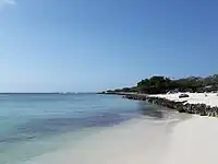 Eagle Beach
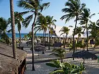 Manchebo Beach
 Mangel Halto Beach
.jpg.webp) Palm Beach
Palm Beach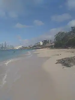 Rodgers Beach
See also
Wikimedia Commons has media related to Aruba.
Wikivoyage has a travel guide for Aruba.
References
- 1 2 3 4 5 6 7 8 9 10 11 12 13 14 "Aruba's Beaches and Coves". Aruba.com. Retrieved September 21, 2021.
- ↑ "Arashi Cove". GeoNames. Retrieved September 21, 2021.
- 1 2 3 4 5 6 7 8 9 10 11 12 13 14 15 16 Google Maps
- ↑ "Druif Beach". GeoNames. Retrieved September 21, 2021.
- ↑ "Eagle Beach". GeoNames. Retrieved September 21, 2021.
- ↑ "Flamingo Beach". GeoNames. Retrieved September 21, 2021.
- ↑ "Iguana Beach". GeoNames. Retrieved September 21, 2021.
- ↑ "Manchebo Beach". GeoNames. Retrieved September 21, 2021.
- ↑ "Palm Beach". GeoNames. Retrieved September 21, 2021.
- ↑ "Rodgers Beach". GeoNames. Retrieved September 21, 2021.
This article is issued from Wikipedia. The text is licensed under Creative Commons - Attribution - Sharealike. Additional terms may apply for the media files.