Belica | |
|---|---|
Municipality | |
_-_centar.JPG.webp) Village centre | |
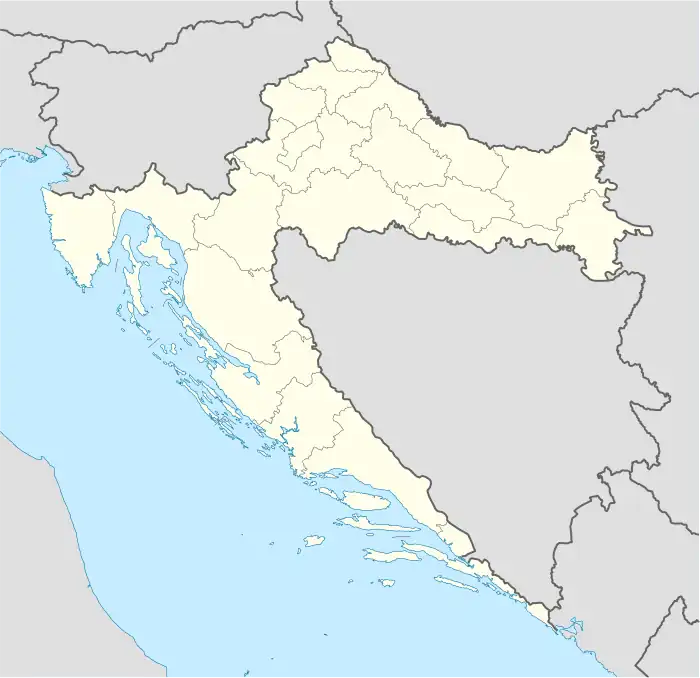 Belica Location of Belica in Croatia | |
| Coordinates: 46°24′N 16°31′E / 46.400°N 16.517°E | |
| Country | |
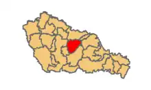
| County | Međimurje |
| Government | |
| • Municipal mayor | Zvonimir Taradi |
| Area | |
| • Municipality | 27.7 km2 (10.7 sq mi) |
| • Urban | 17.1 km2 (6.6 sq mi) |
| Population (2021)[2] | |
| • Municipality | 2,822 |
| • Density | 100/km2 (260/sq mi) |
| • Urban | 2,038 |
| • Urban density | 120/km2 (310/sq mi) |
| Time zone | UTC+1 (CET) |
| • Summer (DST) | UTC+2 (CEST) |
| Postal code | 40319 Belica |
| Website | belica |
Belica (Hungarian: Belica, earlier Belicza) is a village and municipality in Međimurje County, the northernmost county of Croatia. The municipality seat is in the village of Belica, located around 5 kilometres east of Čakovec, the largest city of Međimurje County.
According to the 2011 census, the Belica municipality had a total population of 3,176[3] living in the two villages that the municipality consists of:
- Belica (population 2,278)
- Gardinovec (population 898)
A total of 3,134 people living in the municipality (or 98.68 percent) identified themselves as Croats during the 2011 census.[4]
The municipality is known for its agriculture, especially potato farming. There is even a monument dedicated to potato in Belica, unveiled in August 2007.
There is also a kart circuit between Belica and the nearby village of Pribislavec, as well as a small sports airfield. Both Belica and Gardinovec have their own football clubs, NK BSK Belica and NK Radnički Gardinovec, who compete in local amateur leagues.
References
- ↑ Register of spatial units of the State Geodetic Administration of the Republic of Croatia. Wikidata Q119585703.
- ↑ "Population by Age and Sex, by Settlements, 2021 Census". Census of Population, Households and Dwellings in 2021. Zagreb: Croatian Bureau of Statistics. 2022.
- ↑ "Population by Age and Sex, by Settlements, 2011 Census: Belica". Census of Population, Households and Dwellings 2011. Zagreb: Croatian Bureau of Statistics. December 2012.
- ↑ "Population by Ethnicity, by Towns/Municipalities, 2011 Census: County of Međimurje". Census of Population, Households and Dwellings 2011. Zagreb: Croatian Bureau of Statistics. December 2012.
External links
- Official website (in Croatian)
Subdivisions of Međimurje County | ||
|---|---|---|
| Towns |
| .svg.png.webp) Coat of arms of Međimurje County |
| Municipalities | ||
46°24′N 16°31′E / 46.400°N 16.517°E