Billingborough and Horbling | |
|---|---|
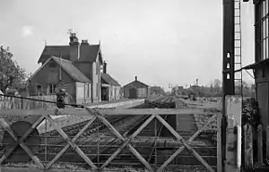 Station in April 1961, before final closure | |
| General information | |
| Location | Billingborough, South Kesteven England |
| Coordinates | 52°53′41″N 0°20′37″W / 52.8946°N 0.3437°W |
| Grid reference | TF115343 |
| Line(s) | Bourne & Sleaford[1] |
| Platforms | 2 |
| Other information | |
| Status | Disused |
| History | |
| Original company | Great Northern Railway |
| Pre-grouping | Great Northern Railway |
| Post-grouping | LNER |
| Key dates | |
| 1872 | opened |
| 1930 | closed (passengers) |
| 1964 | closed (goods) |
Billingborough and Horbling railway station was a station serving the villages of Billingborough, Horbling and Threekingham, Lincolnshire on the Great Northern Railway Bourne and Sleaford railway. It opened in 1872 and closed to passengers in 1930.[2] The section from Bourne to Billingborough remained open for goods until 1964.[3]
| Preceding station | Disused railways | Following station | ||
|---|---|---|---|---|
| Aswarby and Scredington Line and station closed |
Great Northern Railway Bourne and Sleaford Railway |
Rippingale Line and station closed |
References
- ↑ Historic England. "Bourne & Sleaford railway (1365418)". Research records (formerly PastScape). Retrieved 15 December 2010.
- ↑ British Railways Atlas. 1947. p. 17.
- ↑ Historic England. "Billingborough and Horbling station (498482)". Research records (formerly PastScape). Retrieved 15 December 2010.
External links
- England - Lincolnshire (Map). 1:10,560. County series. Ordnance Survey. 1891. p. 124/NE. ; Billingborough and Horbling station on 1891 OS map.
This article is issued from Wikipedia. The text is licensed under Creative Commons - Attribution - Sharealike. Additional terms may apply for the media files.