Blond, Louisiana | |
|---|---|
 Blond, Louisiana  Blond, Louisiana | |
| Coordinates: 30°35′51″N 90°06′04″W / 30.59750°N 90.10111°W | |
| Country | United States |
| State | Louisiana |
| Parish | St. Tammany |
| Elevation | 135 ft (41 m) |
| Time zone | UTC-6 (Central (CST)) |
| • Summer (DST) | UTC-5 (CDT) |
| ZIP code | 70435 |
| Area code | 985 |
| GNIS feature ID | 560226 [1] |
| FIPS code | 22-07905 |
Blond is an unincorporated community in St. Tammany Parish, Louisiana, United States. The community is located on Louisiana Highway 40 approximately 8 mi (13 km) north of Covington and six miles southeast of Folsom.[2]
References
- 1 2 U.S. Geological Survey Geographic Names Information System: Blond, Louisiana
- ↑ Louisiana Atlas & Gazetteer, DeLorme, 3rd ed., 2010, p. 47 ISBN 0899332862
Municipalities and communities of St. Tammany Parish, Louisiana, United States | ||
|---|---|---|
| Cities | 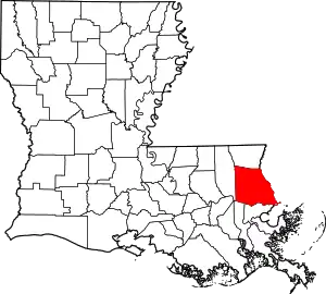 | |
| Towns | ||
| Villages | ||
| CDPs | ||
| Other communities | ||
This article is issued from Wikipedia. The text is licensed under Creative Commons - Attribution - Sharealike. Additional terms may apply for the media files.