Bushtown, Kentucky | |
|---|---|
 Bushtown, Kentucky | |
| Coordinates: 37°46′05″N 84°59′34″W / 37.76806°N 84.99278°W | |
| Country | United States |
| State | Kentucky |
| County | Mercer |
| Elevation | 876 ft (267 m) |
| Time zone | UTC-5 (Eastern (EST)) |
| • Summer (DST) | UTC-4 (EDT) |
| Area code | 859 |
| GNIS feature ID | 507628[1] |
Bushtown is an unincorporated community in Mercer County, Kentucky, United States. Bushtown is located on Kentucky Route 1941, 8.2 miles (13.2 km) west of Harrodsburg.[2]
References
- ↑ "Bushtown". Geographic Names Information System. United States Geological Survey, United States Department of the Interior.
- ↑ State Primary Road System: Mercer County (PDF) (Map). Kentucky Transportation Cabinet. 2011. Retrieved June 11, 2012.
Municipalities and communities of Mercer County, Kentucky, United States | ||
|---|---|---|
| Cities | 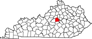 Location of Mercer County, Kentucky | |
| CDP | ||
| Other communities | ||
| Ghost town | ||
This article is issued from Wikipedia. The text is licensed under Creative Commons - Attribution - Sharealike. Additional terms may apply for the media files.