Cabanaconde
Qhawana Kunti | |
|---|---|
 | |
| Country | |
| Region | Arequipa |
| Province | Caylloma |
| Capital | Cabanaconde |
| Government | |
| • Mayor | Jorge Alfredo Guerra Bernedo |
| Area | |
| • Total | 460.55 km2 (177.82 sq mi) |
| Elevation | 3,287 m (10,784 ft) |
| Population | |
| • Total | 2,920 |
| • Density | 6.3/km2 (16/sq mi) |
| Time zone | UTC-5 (PET) |
| UBIGEO | 040503 |
Cabanaconde or Qhawana Kunti (Quechua) is one of twenty districts of the Caylloma Province in Peru.[1]
Geography
One of the highest mountains of the district is Hualca Hualca at 6,025 m (19,767 ft). Other mountains are listed below:[2]
- Jach'umani
- Chuwa Qucha
- Kuntur
- Kuntur Sinqa
- Lipayuq
- Luk'i Urqu
- Pukarilla
- Puru Pakisqa
- Phuyphu
- Wanqarani
- Yaritayuq
Images
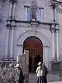 Early morning at the side entrance to the church in Cabanaconde
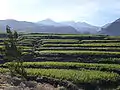 Agricultural terraces of corn near Cabanaconde
See also
References
- ↑ (in Spanish) Instituto Nacional de Estadística e Informática. Banco de Información Distrital Archived April 23, 2008, at the Wayback Machine. Retrieved April 11, 2008.
- ↑ escale.minedu.gob.pe - UGEL maps of the Caylloma Province 1, Arequipa Region
External links
- http://worldtimer.net/Cities/all.php?c=Peru&city=Cabanaconde&country=&k1=-1562&k2=-7198 Time, Weather and Astronomical Data for Cabanaconde.
15°37′S 71°58′W / 15.617°S 71.967°W
This article is issued from Wikipedia. The text is licensed under Creative Commons - Attribution - Sharealike. Additional terms may apply for the media files.