Carazinho | |
|---|---|
| O Município do Carazinho The Municipality of Carazinho | |
 Flag  Seal | |
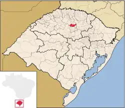 | |
 Carazinho Location in Brazil | |
| Coordinates: 28°17′02″S 52°47′09″W / 28.28389°S 52.78583°W | |
| Country | |
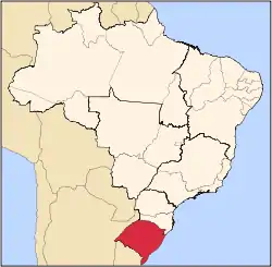
| State | Rio Grande do Sul |
| Region | South |
| Mesoregion | Mesoregion Nordeste Rio-Grandense |
| Microregion | Carazinho |
| Founded | 24 January 1931 |
| Government | |
| • Mayor | Milton Schmitz (MDB) |
| Area | |
| • City | 676 km2 (261 sq mi) |
| Elevation | 603 m (1,978 ft) |
| Population (2020 [1]) | |
| • City | 62,265 |
| • Density | 92/km2 (240/sq mi) |
| • Rural | 1,064 |
| • Metro | 58,253 |
| Demonym | carazinhense |
| Time zone | UTC−3 (BRT) |
| Postal Code | 99500-000 |
| Area code | +55 54 |
| Website | www |
Carazinho is a city located 246 km from Porto Alegre, in the northwest portion of the Brazilian state of Rio Grande do Sul. Carazinho was founded on 1931 and as of 2020 has a population of 62,265. Carazinho's primary economy is focused on agriculture. Soybeans, corn and wheat are the major products.
Carazinho can be accessed via BR-285 or BR-386, which are major roads in Rio Grande do Sul.
It has an elevation of 603 meters and an area of 676 km²
A significant part of Carazinho's population is of German origin.
References
This article is issued from Wikipedia. The text is licensed under Creative Commons - Attribution - Sharealike. Additional terms may apply for the media files.