Casinhas | |
|---|---|
City | |
 | |
| Etymology: Little houses | |
 Casinhas | |
| Coordinates: 07°44′27″S 35°43′15″W / 7.74083°S 35.72083°W | |
| Country | Brazil |
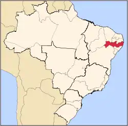
| State | Pernambuco |
| Mesoregion | Agreste of Pernambuco |
| Area | |
| • Total | 125.28 km2 (48.37 sq mi) |
| Elevation | 390 m (1,280 ft) |
| Population (2020 [1]) | |
| • Total | 14,368 |
| • Density | 110/km2 (300/sq mi) |
| Time zone | UTC−3 (BRT) |
Casinhas or little houses (population: 14,368) is a city in northeastern Brazil, in the State of Pernambuco. It lies in the mesoregion of Agreste of Pernambuco and has 125.28 sq/km of total area.
Geography
- State - Pernambuco
- Region - Agreste of Pernambuco
- Boundaries - Paraiba (N), Surubim (S) Bom Jardim and Orobó (E); Vertentes do Lério (W).
- Area - 125.28 km2
- Elevation - 390 m
- Hydrography - Capibaribe and Goiana Rivers
- Vegetation - Caatinga hipoxerófila
- Annual average temperature - 23.3 c
- Distance to Recife - 133 km
Economy
The main economic activities in Casinhas is agribusiness, especially farming of cattle, goats and sheep.
Economic Indicators
| Population [2] | GDP x(1000 R$).[3] | GDP pc (R$) | PE |
|---|---|---|---|
| 14,368 | 38,794 | 2.642 | 0.06% |
Economy by Sector 2006
| Primary sector | Secondary sector | Service sector |
|---|---|---|
| 11.30% | 7.93% | 80.77% |
Health Indicators
| HDI (2000) | Hospitals (2007) | Hospitals beds (2007) | Children's Mortality every 1000 (2005) |
|---|---|---|---|
| 0.588 | 3 | 33 | 10.5 |
References
- ↑ IBGE 2020
- ↑ http://www.ibge.gov.br/home/estatistica/populacao/estimativa2009/POP2009_DOU.pdf IBGE Population 2009 Casinhas, page 32]
- ↑ Casinhas 2007 GDP IBGE page 29 Archived March 4, 2016, at the Wayback Machine
- ↑ PE State site - City by city profile
Capital: Recife | ||||||||||||||
| Mesoregion Agreste Pernambucano |
|  | ||||||||||||
| Mesoregion Mata Pernambucana |
| |||||||||||||
| Mesoregion Metropolitana de Recife |
| |||||||||||||
| Mesoregion Sao Francisco Pernambucano |
| |||||||||||||
| Mesoregion Sertão Pernambucano |
| |||||||||||||
This article is issued from Wikipedia. The text is licensed under Creative Commons - Attribution - Sharealike. Additional terms may apply for the media files.