Native name: Cay Sat | |
|---|---|
 | |
 | |
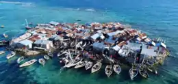
 Caye Sable | |
| Geography | |
| Coordinates | 18°41′42″N 72°45′47″W / 18.69500°N 72.76306°W |
| Area | 0.0016 km2 (0.00062 sq mi) |
| Administration | |
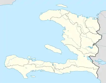
| Department | Ouest |
| Arrondissement | La Gonâve |
| Commune | Anse-à-Galets |
| Demographics | |
| Population | 250 |
| Pop. density | 156,250/km2 (404690/sq mi) |
Caye Sable (Haitian Creole: Cay Sab) is a small island of Haiti located in the Anse-à-Galets commune, about 50 km west of Port-au-Prince. It is known for being the most densely populated islands in the world, with around 250-300 people sharing an area of 0.16 hectares (0.40 acres) in about 75 houses.[1]
The island is a cay accessible by small boats from the village of Petite Anse in the extreme south of Gonâve Island. There is no source of fresh water on the island.
See also
References
- ↑ Migliore, Carlo (26 March 2018). "Caye Sable, Haiti. Un puntino sovraffollato nel Mar dei Caraibi. VIDEO". 3bmeteo.com. Retrieved 6 December 2021.
This article is issued from Wikipedia. The text is licensed under Creative Commons - Attribution - Sharealike. Additional terms may apply for the media files.