Cedar Creek, Arizona | |
|---|---|
 Location of Cedar Creek in Gila County, Arizona. | |
 Cedar Creek  Cedar Creek | |
| Coordinates: 33°53′44″N 110°10′25″W / 33.89556°N 110.17361°W | |
| Country | United States |
| State | Arizona |
| County | Gila |
| Area | |
| • Total | 17.04 sq mi (44.12 km2) |
| • Land | 17.04 sq mi (44.12 km2) |
| • Water | 0.00 sq mi (0.00 km2) |
| Elevation | 4,928 ft (1,502 m) |
| Population (2020) | |
| • Total | 372 |
| • Density | 21.84/sq mi (8.43/km2) |
| Time zone | UTC-7 (Mountain (MST)) |
| ZIP code | 85542[2] |
| Area code | 928 |
| GNIS feature ID | 2619 |
Cedar Creek is a census-designated place in Gila County, Arizona, United States, on the Fort Apache Indian Reservation. Cedar Creek is located along Arizona State Route 73. The population in 2010 was 318.[3]
Geography
Cedar Creek is located at 33°53′29″N 110°11′45″W / 33.891399°N 110.195707°W.
According to the U.S. Census Bureau, the community has an area of 17.035 square miles (44.12 km2), all land.[4]
Demographics
| Census | Pop. | Note | %± |
|---|---|---|---|
| 2020 | 372 | — | |
| U.S. Decennial Census[5] | |||
Transportation
The White Mountain Apache Tribe operates the Fort Apache Connection Transit, which provides local bus service.[6]
References
- ↑ "2020 U.S. Gazetteer Files". United States Census Bureau. Retrieved October 29, 2021.
- ↑ "Cedar Creek AZ ZIP Code". zipdatamaps.com. 2023. Retrieved May 3, 2023.
- ↑ "2010 Census Interactive Population Search". census.gov. Archived from the original on April 13, 2014. Retrieved April 13, 2014.
- ↑ "2010 Census Gazetteer Files: Places – Arizona". U.S. Census Bureau. Archived from the original on September 6, 2013. Retrieved July 16, 2014.
- ↑ "Census of Population and Housing". Census.gov. Retrieved June 4, 2016.
- ↑ "Tribal Transportation". WMAT DOT. Retrieved February 3, 2020.
Municipalities and communities of Gila County, Arizona, United States | ||
|---|---|---|
| City | 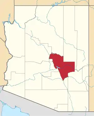 | |
| Towns | ||
| CDPs |
| |
| Populated places | ||
| Indian reservations | ||
| Ghost towns | ||
| Footnotes | ‡This populated place also has portions in an adjacent county or counties | |
This article is issued from Wikipedia. The text is licensed under Creative Commons - Attribution - Sharealike. Additional terms may apply for the media files.