Ceres, Virginia | |
|---|---|
Unincorporated community | |
 Post office | |
 Ceres, Virginia  Ceres, Virginia | |
| Coordinates: 37°01′04″N 81°20′34″W / 37.01778°N 81.34278°W | |
| Country | United States |
| State | Virginia |
| County | Bland |
| Elevation | 2,582 ft (787 m) |
| Time zone | UTC-5 (Eastern (EST)) |
| • Summer (DST) | UTC-4 (EDT) |
| ZIP code | 24318 |
| Area code | 276 |
| GNIS feature ID | 1494870[1] |
Ceres is an unincorporated community in Bland County, Virginia, United States. Ceres is located on State Route 42 13.5 miles (21.7 km) west-southwest of Bland. Ceres has a post office with ZIP code 24318.[2]
Climate
The climate in this area has mild differences between highs and lows, and there is adequate rainfall year-round. According to the Köppen Climate Classification system, Ceres has a marine west coast climate, abbreviated "Cfb" on climate maps.[3]
References
Municipalities and communities of Bland County, Virginia, United States | ||
|---|---|---|
| CDPs | 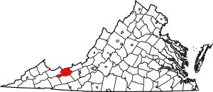 Map of Virginia highlighting Bland County | |
| Other communities | ||
This article is issued from Wikipedia. The text is licensed under Creative Commons - Attribution - Sharealike. Additional terms may apply for the media files.