Clyde, Wisconsin | |
|---|---|
 Clyde  Clyde | |
| Coordinates: 43°07′10″N 90°12′41″W / 43.11944°N 90.21139°W | |
| Country | |
| State | |
| County | Iowa |
| Town | Clyde |
| Elevation | 224 m (735 ft) |
| Time zone | UTC-6 (Central (CST)) |
| • Summer (DST) | UTC-5 (CDT) |
| Area code | 608 |
| GNIS feature ID | 1577550[1] |
Clyde is an unincorporated community located in the town of Clyde, Iowa County, Wisconsin, United States. Clyde is located at the junction of Wisconsin Highway 130 and County Highway I along Otter Creek, 11.7 miles (18.8 km) north-northwest of Dodgeville.[2] The community was named by Seth Champion, a director of the Kewaunee, Green Bay & Western railroad in the 1890s, for his son Clyde.[3]
References
- ↑ U.S. Geological Survey Geographic Names Information System: Clyde (community), Iowa County, Wisconsin
- ↑ Iowa County (PDF) (Map). Wisconsin Department of Transportation. 2011. Archived from the original (PDF) on January 30, 2012. Retrieved December 5, 2011.
- ↑ Callary, Edward. Place Names of Wisconsin. Madison, WI: University of Wisconsin Press. p. 60. ISBN 978-0-299-30964-0.
Municipalities and communities of Iowa County, Wisconsin, United States | ||
|---|---|---|
| Cities | 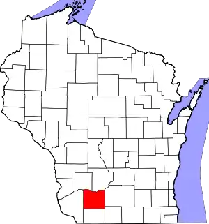 | |
| Villages | ||
| Towns | ||
| CDP | ||
| Unincorporated communities | ||
| Ghost towns | ||
| Footnotes | ‡This populated place also has portions in an adjacent county or counties | |
This article is issued from Wikipedia. The text is licensed under Creative Commons - Attribution - Sharealike. Additional terms may apply for the media files.