Dahoga, Pennsylvania | |
|---|---|
Unincorporated community | |
 Dahoga | |
| Coordinates: 41°35′57″N 78°43′26″W / 41.59917°N 78.72389°W | |
| Country | United States |
| State | Pennsylvania |
| County | Elk |
| Township | Jones |
| Elevation | 1,614 ft (492 m) |
| Time zone | UTC-5 (Eastern (EST)) |
| • Summer (DST) | UTC-4 (EDT) |
| Area code | 814 |
| GNIS feature ID | 1209542[1] |
Dahoga is an unincorporated community in Jones Township in Elk County, Pennsylvania, United States. Dahoga is located along Pennsylvania Route 321, northwest of Wilcox.[2]
References
- ↑ "Dahoga". Geographic Names Information System. United States Geological Survey, United States Department of the Interior.
- ↑ Elk County, Pennsylvania Highway Map (PDF) (Map). PennDOT. 2014. Retrieved September 28, 2015.
Municipalities and communities of Elk County, Pennsylvania, United States | ||
|---|---|---|
| City | 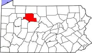 | |
| Boroughs | ||
| Townships | ||
| CDPs | ||
| Unincorporated communities | ||
This article is issued from Wikipedia. The text is licensed under Creative Commons - Attribution - Sharealike. Additional terms may apply for the media files.