Dorsey, Mississippi | |
|---|---|
 Dorsey  Dorsey | |
| Coordinates: 34°15′07″N 88°30′35″W / 34.25194°N 88.50972°W | |
| Country | United States |
| State | Mississippi |
| County | Itawamba |
| Elevation | 381 ft (116 m) |
| Time zone | UTC-6 (Central (CST)) |
| • Summer (DST) | UTC-5 (CDT) |
| ZIP code | 38855 |
| Area code | 662 |
| GNIS feature ID | 669333[1] |
Dorsey is an unincorporated community located in Itawamba County, Mississippi. Dorsey is approximately 4 miles (6.4 km) west of Fulton and approximately 6 miles (9.7 km) east of Mooreville near Mississippi Highway 178. A post office operated under the name Dorsey from 1897 to 1971.[2]
References
- ↑ U.S. Geological Survey Geographic Names Information System: Dorsey, Mississippi
- ↑ "Itawamba County". Jim Forte Postal History. Retrieved August 1, 2021.
Municipalities and communities of Itawamba County, Mississippi, United States | ||
|---|---|---|
| City | 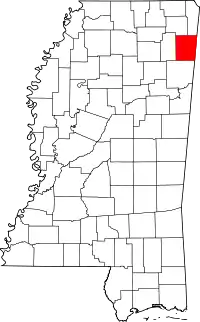 Map of Mississippi highlighting Itawamba County | |
| Towns | ||
| CDP | ||
| Other communities | ||
| Ghost towns | ||
This article is issued from Wikipedia. The text is licensed under Creative Commons - Attribution - Sharealike. Additional terms may apply for the media files.