Edu | |
|---|---|
 Edu | |
| Coordinates: 8°53′31″N 5°12′36″E / 8.8919°N 5.21°E | |
| Country | |
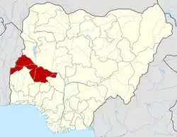
| State | Kwara State |
| Etsu | 1830 |
| Time zone | UTC+1 (WAT) |
Edu is a Local Government Area in Kwara State. A Nupe speaking area in Nigeria. Edu consists of Lafiagi, Tsaragi and Tshonga Town. Its headquarters are in the town of Lafiagi.
It has an area of 2,542 km2 and a population of 201,469 as of the 2006 census.
The postal code of the area is 243.[1]
References
- ↑ "Post Offices- with map of LGA". NIPOST. Archived from the original on 2009-10-07. Retrieved 2009-10-20.
State capital: Ilorin | ||
| Governors |
|  |
| LGAs | ||
| Cities | ||
| Towns |
| |
This article is issued from Wikipedia. The text is licensed under Creative Commons - Attribution - Sharealike. Additional terms may apply for the media files.