Enid, Mississippi | |
|---|---|
 Enid, Mississippi  Enid, Mississippi | |
| Coordinates: 34°06′59″N 89°56′20″W / 34.11639°N 89.93889°W | |
| Country | United States |
| State | Mississippi |
| County | Tallahatchie |
| Elevation | 308 ft (94 m) |
| Time zone | UTC-6 (Central (CST)) |
| • Summer (DST) | UTC-5 (CDT) |
| ZIP code | 38927 |
| Area code | 662 |
| GNIS feature ID | 693174[1] |
Enid is an unincorporated community located in Tallahatchie County, Mississippi, United States. Enid is located near U.S. Highway 51 approximately 7 miles (11 km) north of Oakland, Mississippi and approximately 9 miles (14 km) south of Pope, Mississippi.
Although Enid is an unincorporated community, it has a post office and a zip code of 38927.
References
Municipalities and communities of Tallahatchie County, Mississippi, United States | ||
|---|---|---|
| City | 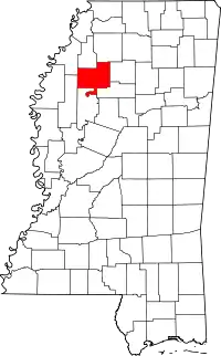 Map of Mississippi highlighting Tallahatchie County | |
| Towns | ||
| Village | ||
| Unincorporated communities | ||
| Ghost towns | ||
| Footnotes | ‡This populated place also has portions in an adjacent county or counties | |
This article is issued from Wikipedia. The text is licensed under Creative Commons - Attribution - Sharealike. Additional terms may apply for the media files.