Epitaciolândia | |
|---|---|
 | |
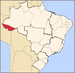
 Location of municipality in Acre State | |
 Epitaciolândia Location in Brazil | |
| Coordinates: 11°01′44″S 68°44′27″W / 11.02889°S 68.74083°W | |
| Country | |
| State | Acre |
| Government | |
| • Mayor | Tião Flores (PSB) |
| Area | |
| • Total | 1,659 km2 (641 sq mi) |
| Population (2020 est) | |
| • Total | 18,696 |
| Time zone | UTC−5 (ACT) |
Epitaciolândia (Portuguese pronunciation: [epitasjuˈlɐ̃dʒi.ɐ]) is a municipality located in the southeast of state of Acre. Its population is 18,696 inhabitants and its area is 1,659 km². It is the southernmost municipality in Acre.
The municipality contains part of the 931,537 hectares (2,301,880 acres) Chico Mendes Extractive Reserve, a sustainable use environmental unit created in 1990.[1]
References
- ↑ Unidade de Conservação: Reserva Extrativista Chico Mendes (in Portuguese), MMA: Ministério do Meio Ambiente, retrieved 2016-06-04
This article is issued from Wikipedia. The text is licensed under Creative Commons - Attribution - Sharealike. Additional terms may apply for the media files.