Fairview Crossroads, South Carolina | |
|---|---|
 Fairview Crossroads  Fairview Crossroads | |
| Coordinates: 33°45′31″N 81°21′59″W / 33.75861°N 81.36639°W | |
| Country | United States |
| State | South Carolina |
| County | Lexington |
| Area | |
| • Total | 5.72 sq mi (14.81 km2) |
| • Land | 5.71 sq mi (14.79 km2) |
| • Water | 0.01 sq mi (0.01 km2) |
| Elevation | 469 ft (143 m) |
| Population | |
| • Total | 540 |
| • Density | 94.55/sq mi (36.51/km2) |
| Time zone | UTC-5 (Eastern (EST)) |
| • Summer (DST) | UTC-4 (EDT) |
| ZIP Code | 29070 (Leesville) |
| Area code(s) | 803/839 |
| FIPS code | 45-24865 |
| GNIS feature ID | 2807070[2] |
Fairview Crossroads is an unincorporated community and census-designated place (CDP) in Lexington County, South Carolina, United States. It was first listed as a CDP prior to the 2020 census[2] with a population of 540.[4]
The CDP is in southern Lexington County, centered on the junction of U.S. Route 178 and South Carolina Highway 113. US 178 leads northwest 15 miles (24 km) to Batesburg-Leesville and southeast 7 miles (11 km) to Pelion, while Highway 113 leads south 7 miles (11 km) to Wagener.
Demographics
| Census | Pop. | Note | %± |
|---|---|---|---|
| 2020 | 540 | — | |
| U.S. Decennial Census[5] 2020[6][3] | |||
2020 census
| Race / Ethnicity | Pop 2020[6] | % 2020 |
|---|---|---|
| White alone (NH) | 461 | 85.37% |
| Black or African American alone (NH) | 18 | 3.33% |
| Native American or Alaska Native alone (NH) | 2 | 0.37% |
| Asian alone (NH) | 1 | 0.19% |
| Pacific Islander alone (NH) | 0 | 0.00% |
| Some Other Race alone (NH) | 2 | 0.37% |
| Mixed Race/Multi-Racial (NH) | 29 | 5.37% |
| Hispanic or Latino (any race) | 27 | 5.00% |
| Total | 540 | 100.00% |
Note: the US Census treats Hispanic/Latino as an ethnic category. This table excludes Latinos from the racial categories and assigns them to a separate category. Hispanics/Latinos can be of any race.
References
- ↑ "ArcGIS REST Services Directory". United States Census Bureau. Retrieved October 15, 2022.
- 1 2 3 U.S. Geological Survey Geographic Names Information System: Fairview Crossroads, South Carolina
- 1 2 "Census Population API". United States Census Bureau. Retrieved October 15, 2022.
- ↑ "Fairview Crossroads CDP, South Carolina". United States Census Bureau. Retrieved April 7, 2022.
- ↑ "Decennial Census of Population and Housing by Decades". US Census Bureau.
- 1 2 "P2 HISPANIC OR LATINO, AND NOT HISPANIC OR LATINO BY RACE – 2020: DEC Redistricting Data (PL 94-171) – Fairview Crossroads CDP, South Carolina". United States Census Bureau.
Municipalities and communities of Lexington County, South Carolina, United States | ||
|---|---|---|
| Cities | 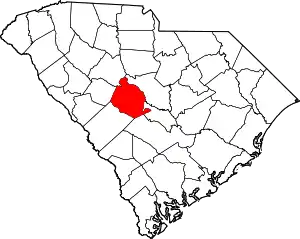 Map of South Carolina highlighting Lexington County | |
| Towns | ||
| CDPs | ||
| Ghost town | ||
| Footnotes | ‡This populated place also has portions in an adjacent county or counties | |
This article is issued from Wikipedia. The text is licensed under Creative Commons - Attribution - Sharealike. Additional terms may apply for the media files.