Fenoambany | |
|---|---|
 Fenoambany Location in Madagascar | |
| Coordinates: 23°49′S 47°33′E / 23.817°S 47.550°E | |
| Country | |
| Region | Atsimo-Atsinanana |
| District | Vangaindrano |
| Elevation | 8 m (26 ft) |
| Population (2001)[2] | |
| • Total | 7,000 |
| Time zone | UTC3 (EAT) |
Fenoambany is a town and commune in the Madagascar district of Vangaindrano, part of Atsimo-Atsinanana and home to about 7,000 people in the 2001 commune census.[2]
Fenoambany has a primary school. The majority (94%) of the population are farmers. The most important crops are rice and coffee, followed by cloves and black pepper. The service industry employs 1% of the population and fishing 5%.[2]
References and notes
- ↑ Estimated based on DEM data from Shuttle Radar Topography Mission
- 1 2 3 "ILO census data". Cornell University. 2002. Retrieved 2008-05-05.
Capital: Farafangana | ||
| Befotaka Sud (6) - 307 | 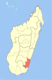 | |
| Farafangana (30) - 309 |
| |
| Midongy-Atsimo (6) - 318 | ||
| Vangaindrano (28) - 320 | ||
| Vondrozo (16) - 322 | ||
5 districts; 86 communes | ||
23°49′S 47°33′E / 23.817°S 47.550°E
This article is issued from Wikipedia. The text is licensed under Creative Commons - Attribution - Sharealike. Additional terms may apply for the media files.