Gallows Hill, Pennsylvania | |
|---|---|
Unincorporated community | |
 Gallows Hill | |
| Coordinates: 40°31′50″N 75°13′19″W / 40.53056°N 75.22194°W | |
| Country | United States |
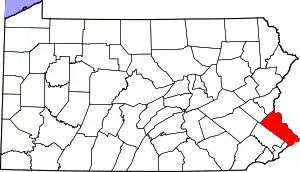
| State | Pennsylvania |
| County | Bucks |
| Township | Springfield |
| Elevation | 617 ft (188 m) |
| Time zone | UTC-5 (Eastern (EST)) |
| • Summer (DST) | UTC-4 (EDT) |
| ZIP code | 18930 |
| Area code(s) | 610 and 484 |
| GNIS feature ID | 1173597[1] |
| Designated | 1925[2] |
Gallows Hill is an unincorporated community in Springfield Township in Bucks County, Pennsylvania, United States. Gallows Hill is located at the intersection of Pennsylvania Route 412 and Stony Garden Road/Gallows Hill Road.[3]
Etymology
The community's name was derived from an 18th-century traveler who hanged himself from a tree.[4]
References
- ↑ "Gallows Hill". Geographic Names Information System. United States Geological Survey, United States Department of the Interior.
- ↑ "PHMC Historical Markers Search" (Searchable database). Pennsylvania Historical and Museum Commission. Commonwealth of Pennsylvania. Retrieved January 25, 2014.
- ↑ Bucks County, Pennsylvania (Map) (19th ed.). 1"=2000'. ADC Map. 2006. p. 2583. § E5. ISBN 0-87530-774-4.
- ↑ Davis, William Watts Hart (1905). History of Bucks County, Pennsylvania: From the Discovery of the Delaware to the Present Time. Lewis Publishing Company. p. 38.
This article is issued from Wikipedia. The text is licensed under Creative Commons - Attribution - Sharealike. Additional terms may apply for the media files.