Green Acres, North Dakota | |
|---|---|
 Green Acres, North Dakota | |
| Coordinates: 48°50′17″N 99°41′24″W / 48.83806°N 99.69000°W | |
| Country | United States |
| State | North Dakota |
| County | Rolette |
| Area | |
| • Total | 1.50 sq mi (3.90 km2) |
| • Land | 1.50 sq mi (3.90 km2) |
| • Water | 0.00 sq mi (0.00 km2) |
| Elevation | 1,923 ft (586 m) |
| Population (2020) | |
| • Total | 605 |
| • Density | 401.99/sq mi (155.21/km2) |
| Time zone | UTC-6 (CST) |
| • Summer (DST) | UTC-5 (CDT) |
| ZIP Code | 58316 |
| Area code | 701 |
| GNIS feature ID | 2584344[2] |
Green Acres is a census-designated place in Rolette County, North Dakota, United States. Its population was 605 as of the 2020 census.[3]
Demographics
| Census | Pop. | Note | %± |
|---|---|---|---|
| 1990 | 177 | — | |
| 2000 | 109 | −38.4% | |
| 2010 | 575 | 427.5% | |
| 2020 | 605 | 5.2% | |
| U.S. Decennial Census[4] 2020 Census[3] | |||
Education
The local school district is the Belcourt School District (Turtle Mountain Community School).[5]
References
- ↑ "ArcGIS REST Services Directory". United States Census Bureau. Retrieved September 20, 2022.
- 1 2 U.S. Geological Survey Geographic Names Information System: Green Acres, North Dakota
- 1 2 "Explore Census Data". Explore Census Data. United States Census Bureau. Retrieved May 24, 2022.
- ↑ United States Census Bureau. "Census of Population and Housing". Retrieved January 19, 2014.
- ↑ "2020 CENSUS - SCHOOL DISTRICT REFERENCE MAP: Rolette County, ND" (PDF). United States Census Bureau. Retrieved August 4, 2021.
Municipalities and communities of Rolette County, North Dakota, United States | ||
|---|---|---|
| Cities | 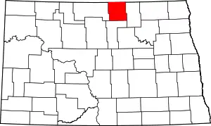 Map of North Dakota highlighting Rolette County | |
| Townships |
| |
| Unorganized territories |
| |
| CDPs | ||
| Other communities | ||
| Indian reservation | ||
| Footnotes | ‡This populated place also has portions in an adjacent county or counties | |
This article is issued from Wikipedia. The text is licensed under Creative Commons - Attribution - Sharealike. Additional terms may apply for the media files.