Habscht | |
|---|---|
.jpg.webp) | |
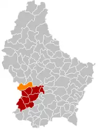 Map of Luxembourg with Habscht highlighted in orange, and the canton in dark red | |
| Coordinates: 49°41′18″N 5°54′54″E / 49.68833°N 5.91500°E | |
| Country | |
| Canton | Capellen |
| Area | |
| • Total | 32.51 km2 (12.55 sq mi) |
| • Rank | 21st of 102 |
| Highest elevation | 391 m (1,283 ft) |
| • Rank | 60th of 102 |
| Lowest elevation | 242 m (794 ft) |
| • Rank | 51st of 102 |
| Population (2023) | |
| • Total | 4,992 |
| • Rank | 35th of 102 |
| • Density | 150/km2 (400/sq mi) |
| • Rank | 55th of 102 |
| Time zone | UTC+1 (CET) |
| • Summer (DST) | UTC+2 (CEST) |
| LAU 2 | LU0000103 |
Habscht is a commune in central Luxembourg, in the canton of Capellen.
It was established on 1 January 2018 from the amalgamation of the communes of Hobscheid and Septfontaines.[1][2]
Populated places
The commune consists of the following villages:
|
References
- ↑ wort.lu: "Ja" aus Simmern, Böwingen, Tüntingen, Eschweiler und Wiltz, retrieved 14 February 2015.
- ↑ wort.lu: "Ja" zur "Gemeng Habscht", retrieved 14 February 2015.
Places adjacent to Habscht | |
|---|---|

This article is issued from Wikipedia. The text is licensed under Creative Commons - Attribution - Sharealike. Additional terms may apply for the media files.