Hamamatsuchō
浜松町 | |
|---|---|
District | |
.jpg.webp) 2-chōme | |
| Coordinates: 35°39′28″N 139°45′25″E / 35.657767°N 139.756893°E | |
| Country | Japan |
| City | Tokyo |
| Ward | Minato |
| Area | Shiba Area |
| Area | |
| • Total | 0.19 ha (0.47 acres) |
| Population (2019) | |
| • Total | 2,284 |
| • Density | 12,021/km2 (31,130/sq mi) |
| Time zone | UTC+9 (JST) |
| Area code | 03 |
Hamamatsuchō (浜松町) is a business and commercial district south of Shinbashi district in Minato ward in Tokyo, Japan.[1] Hamamatsucho is located along the Tokyo Bay, with views of Odaiba and the Rainbow Bridge.
Companies based in Hamamatsuchō
History
Places in Hamamatsucho
- Hamamatsuchō Station - Served by the JR Yamanote Line, Keihin Tōhoku Line, and the Tokyo Monorail. The latter links Hamamatsuchō with Haneda Airport.
- There is a working replica of the Manneken Pis sculpture at Hamamatsuchō Station, which is dressed by station workers in various costumes at different times of year.[3]
- Kyū Shiba Rikyū Garden
- World Trade Center Building
Transportation
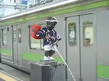
A Japanese variant of Manneken Pis at Hamamatsucho Station
Public transport
Education
Minato City Board of Education operates public elementary and junior high schools.
Hamamatsuchō 1-2-chōme are zoned to Onarimon Elementary School (御成門小学校) and Onarimon Junior High School (御成門中学校).[4]
Gallery
.jpg.webp) Looking down at Hamamatsucho
Looking down at Hamamatsucho
References
- ↑ "Hamamatsucho".
- ↑ "Corporate Information Archived 2015-02-05 at the Wayback Machine." KYB Corporation. Retrieved on February 5, 2015.
- ↑ "Syakyou. kozou". Archived from the original on 2011-11-19. Retrieved 2011-12-16.
- ↑ "港区立小・中学校通学区域一覧表(令和4年4月以降)" (PDF). City of Minato. Retrieved 2022-10-08.
This article is issued from Wikipedia. The text is licensed under Creative Commons - Attribution - Sharealike. Additional terms may apply for the media files.