Hardaway, Alabama | |
|---|---|
 Hardaway  Hardaway | |
| Coordinates: 32°17′12″N 85°50′56″W / 32.28667°N 85.84889°W | |
| Country | United States |
| State | Alabama |
| County | Macon |
| Elevation | 253 ft (77 m) |
| Time zone | UTC-6 (Central (CST)) |
| • Summer (DST) | UTC-5 (CDT) |
| ZIP code | 36039 |
| Area code | 334 |
| GNIS feature ID | 119711[1] |
Hardaway is an unincorporated community in Macon County, Alabama, United States, located 12.9 miles (20.8 km) southwest of Tuskegee. Hardaway has a post office with ZIP code 36039.[2][3]
Demographics
| Census | Pop. | Note | %± |
|---|---|---|---|
| 1900 | 200 | — | |
| 1910 | 300 | 50.0% | |
| 1920 | 310 | 3.3% | |
| U.S. Decennial Census[4] | |||
From 1900 to 1920, Hardaway was listed as a village in 1900 & 1910 and as an incorporated town on the U.S. Census in 1920. It did not appear on the census after that point, likely due to disincorporation.
References
- ↑ "Hardaway". Geographic Names Information System. United States Geological Survey, United States Department of the Interior.
- ↑ United States Postal Service (2012). "USPS - Look Up a ZIP Code". Retrieved February 15, 2012.
- ↑ "Postmaster Finder - Post Offices by ZIP Code". United States Postal Service. Archived from the original on October 17, 2020. Retrieved June 5, 2013.
- ↑ "U.S. Decennial Census". Census.gov. Retrieved June 6, 2013.
Municipalities and communities of Macon County, Alabama, United States | ||
|---|---|---|
| City | 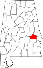 Map of Alabama highlighting Macon County | |
| Towns | ||
| Unincorporated communities | ||
| Footnotes | ‡This populated place also has portions in an adjacent county or counties | |
This article is issued from Wikipedia. The text is licensed under Creative Commons - Attribution - Sharealike. Additional terms may apply for the media files.