Herøysund | |
|---|---|
Village | |
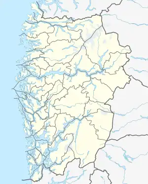 Herøysund Location of the village  Herøysund Herøysund (Norway) | |
| Coordinates: 59°55′09″N 05°47′30″E / 59.91917°N 5.79167°E | |
| Country | Norway |
| Region | Western Norway |
| County | Vestland |
| District | Sunnhordland |
| Municipality | Kvinnherad |
| Area | |
| • Total | 0.47 km2 (0.18 sq mi) |
| Elevation | 19 m (62 ft) |
| Population (2019)[1] | |
| • Total | 506 |
| • Density | 1,077/km2 (2,790/sq mi) |
| Time zone | UTC+01:00 (CET) |
| • Summer (DST) | UTC+02:00 (CEST) |
| Post Code | 5462 Herøysundet |
Herøysund is a village in Kvinnherad municipality in Vestland county, Norway. The village is located on the southeastern shore of the Hardangerfjorden, about half-way between the villages of Husnes (to the south) and Uskedal (to the north). The 0.47-square-kilometre (120-acre) village has a population (2019) of 506 and a population density of 1,077 inhabitants per square kilometre (2,790/sq mi).[1]
References
- 1 2 3 Statistisk sentralbyrå (1 January 2019). "Urban settlements. Population and area, by municipality".
- ↑ "Herøysund, Kvinnherad (Hordaland)" (in Norwegian). yr.no. Retrieved 19 March 2015.
This article is issued from Wikipedia. The text is licensed under Creative Commons - Attribution - Sharealike. Additional terms may apply for the media files.