Herbolzheim | |
|---|---|
 Herbolzheim | |
 Coat of arms | |
Location of Herbolzheim within Emmendingen district 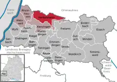 | |
 Herbolzheim 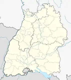 Herbolzheim | |
| Coordinates: 48°13′19″N 7°46′39″E / 48.22194°N 7.77750°E | |
| Country | Germany |
| State | Baden-Württemberg |
| Admin. region | Freiburg |
| District | Emmendingen |
| Subdivisions | 5 |
| Government | |
| • Mayor (2017–25) | Thomas Gedemer[1] |
| Area | |
| • Total | 35.48 km2 (13.70 sq mi) |
| Elevation | 177 m (581 ft) |
| Population (2021-12-31)[2] | |
| • Total | 11,156 |
| • Density | 310/km2 (810/sq mi) |
| Time zone | UTC+01:00 (CET) |
| • Summer (DST) | UTC+02:00 (CEST) |
| Postal codes | 79336 |
| Dialling codes | 07643 |
| Vehicle registration | EM |
| Website | www.herbolzheim.de |
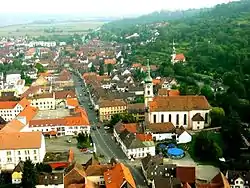
Herbolzheim (German pronunciation: [ˈhɛʁbɔlt͡sˌhaɪ̯m] ⓘ) is a town in the district of Emmendingen, in Baden-Württemberg, Germany. It is situated near the river Elz, 26 km north of Freiburg.
References
- ↑ Aktuelle Wahlergebnisse, Staatsanzeiger, accessed 11 September 2021.
- ↑ "Bevölkerung nach Nationalität und Geschlecht am 31. Dezember 2021" [Population by nationality and sex as of December 31, 2021] (CSV) (in German). Statistisches Landesamt Baden-Württemberg. June 2022.
External links
- (in German) Official Webpage
- (in German) Herbolzheim: History and images Archived 2017-06-23 at the Wayback Machine
Towns and municipalities in Emmendingen (district) | ||
|---|---|---|
Coat of arms | ||
This article is issued from Wikipedia. The text is licensed under Creative Commons - Attribution - Sharealike. Additional terms may apply for the media files.