Honda, California | |
|---|---|
 Honda, California  Honda, California | |
| Coordinates: 34°36′56″N 120°38′01″W / 34.61556°N 120.63361°W | |
| Country | United States |
| State | California |
| County | Santa Barbara |
| Elevation | 92 ft (28 m) |
| Time zone | UTC-8 (Pacific (PST)) |
| • Summer (DST) | UTC-7 (PDT) |
| Area code(s) | 805 & 820 |
| GNIS feature ID | 1660767[1] |
Honda (Spanish for "Depth") is an unincorporated community in Santa Barbara County, California, United States. The community is on the Pacific coast 10.1 miles (16.3 km) west of Lompoc.[2]
References
- ↑ "Honda". Geographic Names Information System. United States Geological Survey, United States Department of the Interior.
- ↑ California Department of Transportation (2005). State Highway Map 2005 (Map). Retrieved June 6, 2019 – via David Rumsey Historical Map Collection.
Municipalities and communities of Santa Barbara County, California, United States | ||
|---|---|---|
| Cities | 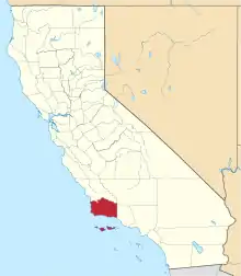 Santa Barbara County map | |
| CDPs | ||
| Unincorporated communities | ||
| Indian reservation | ||
| Ghost towns | ||
This article is issued from Wikipedia. The text is licensed under Creative Commons - Attribution - Sharealike. Additional terms may apply for the media files.