Hrádek | |
|---|---|
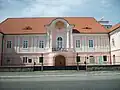
.jpg.webp) View from the southeast | |
 Flag  Coat of arms | |
 Hrádek Location in the Czech Republic | |
| Coordinates: 49°15′49″N 13°29′43″E / 49.26361°N 13.49528°E | |
| Country | |
| Region | Plzeň |
| District | Klatovy |
| First mentioned | 1298 |
| Area | |
| • Total | 36.90 km2 (14.25 sq mi) |
| Elevation | 485 m (1,591 ft) |
| Population (2023-01-01)[1] | |
| • Total | 1,357 |
| • Density | 37/km2 (95/sq mi) |
| Time zone | UTC+1 (CET) |
| • Summer (DST) | UTC+2 (CEST) |
| Postal codes | 342 01 |
| Website | www |
Hrádek is a municipality and village in Klatovy District in the Plzeň Region of the Czech Republic. It has about 1,400 inhabitants.
Hrádek lies approximately 22 kilometres (14 mi) south-east of Klatovy, 55 km (34 mi) south of Plzeň, and 114 km (71 mi) south-west of Prague.
Administrative parts
Villages of Čejkovy, Čermná, Kašovice, Odolenov, Tedražice and Zbynice are administrative parts of Hrádek.
Gallery
 Hrádek Castle
 An area in front of the castle
 Church of Saint Lawrence
References
Wikimedia Commons has media related to Hrádek (Klatovy District).
This article is issued from Wikipedia. The text is licensed under Creative Commons - Attribution - Sharealike. Additional terms may apply for the media files.