| Huveaune | |
|---|---|
 The source of the Huveaune | |
  | |
| Native name | L'Huveaune (French) |
| Location | |
| Country | France |
| Physical characteristics | |
| Source | |
| • location | Sainte-Baume |
| • elevation | 590 m (1,940 ft) |
| Mouth | Mediterranean Sea |
• location | Marseille |
• coordinates | 43°15′34″N 5°22′24″E / 43.2594°N 5.3734°E |
| Length | 48.5 km (30.1 mi) |
| Basin size | 502 km2 (194 sq mi) |
| Discharge | |
| • average | 10 m3/s (350 cu ft/s) |
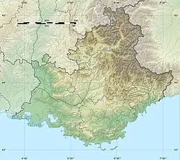
The Huveaune (French pronunciation: [yvon]; Occitan: Evèuna) is a small river in the Provence-Alpes-Côte d'Azur region of southeastern France. It is 48.5 kilometres (30.1 mi) long and flows through the communes of La Penne-sur-Huveaune, Nans-les-Pins, Saint-Zacharie, Plan-d'Aups-Sainte-Baume, Auriol, Roquevaire, Aubagne, and the metropolitan area of Marseille.[1]
The Huveaune rises in the Castelette cave at 590 metres (1,940 ft) in the Sainte-Baume mountain range, and runs into the Mediterranean Sea at Marseille. Its drainage basin is 502 km2 (194 sq mi).[2]

The Huveaune river bed in Aubagne during the July 2022 heatwave.

Dry riverbed of the Huveaune at St Giniez, near Marseilles
References
- ↑ Sandre. "Fiche cours d'eau - L'Huveaune (Y44-0400 )".
- ↑ Bassin versant : Huveaune (L'), Observatoire Régional Eau et Milieux Aquatiques en PACA
Wikimedia Commons has media related to Huveaune.
This article is issued from Wikipedia. The text is licensed under Creative Commons - Attribution - Sharealike. Additional terms may apply for the media files.