Istebné | |
|---|---|
Village | |
 General view of the village | |
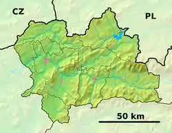 Istebné Location of Istebné in Slovakia  Istebné Istebné (Slovakia) | |
| Coordinates: 49°13′N 19°13′E / 49.217°N 19.217°E | |
| Country | |
| Region | Žilina |
| District | Dolný Kubín |
| First mentioned | 1272 |
| Area | |
| • Total | 11.29[1] km2 (4.36[1] sq mi) |
| Elevation | 490[2] m (1,610[2] ft) |
| Population (2021) | |
| • Total | 1,347[3] |
| Postal code | 027 53[2] |
| Area code | +421 43[2] |
| Car plate | DK |
| Website | www.istebne.sk |
Istebné (Hungarian: Isztebne) is a village and municipality in Dolný Kubín District in the Žilina Region of northern Slovakia.[4]
See also
References
- 1 2 "Hustota obyvateľstva - obce [om7014rr_ukaz: Rozloha (Štvorcový meter)]". www.statistics.sk (in Slovak). Statistical Office of the Slovak Republic. 2022-03-31. Retrieved 2022-03-31.
- 1 2 3 4 "Základná charakteristika". www.statistics.sk (in Slovak). Statistical Office of the Slovak Republic. 2015-04-17. Retrieved 2022-03-31.
- ↑ "Počet obyvateľov podľa pohlavia - obce (ročne)". www.statistics.sk (in Slovak). Statistical Office of the Slovak Republic. 2022-03-31. Retrieved 2022-03-31.
- ↑ DB City.com
Genealogical resources
The records for genealogical research are available at the state archive "Statny Archiv in Bytca, Slovakia"
- Lutheran church records (births/marriages/deaths): 1781-1933 (parish A)
External links
Municipalities of Dolný Kubín District | ||
|---|---|---|
This article is issued from Wikipedia. The text is licensed under Creative Commons - Attribution - Sharealike. Additional terms may apply for the media files.