Jōmon Prehistoric Sites in Northern Japan
UNESCO World Heritage Site
LocationJapan
CriteriaCultural: (iii)(v)
Reference1632
Inscription2021 (44th Session)
Area141.9 ha (0.548 sq mi)
Buffer zone984.8 ha (3.802 sq mi)

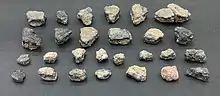
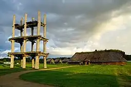
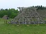
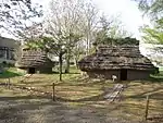
Jōmon Prehistoric Sites in Northern Japan (北海道・北東北の縄文遺跡群) is a serial UNESCO World Heritage Site consisting of 17 Jōmon-period archaeological sites in Hokkaidō and northern Tōhoku, Japan. The Jōmon period lasted more than 10,000 years, representing "sedentary pre-agricultural lifeways and a complex spiritual culture of prehistoric people".[2]

It was first placed on the World Heritage Tentative List in 2009.[3] In 2021, ICOMOS recommended the inscription in July of the revised serial nomination of seventeen sites under criteria iii and v.[4] It was then officially inscribed on the World Heritage List on 27 July 2021.[2]
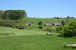
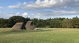
Sites

All component sites have been designated for protection under the Law for the Protection of Cultural Properties, as Historic Sites or *Special Historic Sites ("ACA" column below).[4]

UNESCO ID[5] Site Municipality Prefecture Comments Image Coordinates ACA
1632-001Ōdai Yamamoto I Site
大平山元遺跡
Ōdai Yamamoto iseki
SotogahamaAomoriexcavated earthenware has been dated as early as 16500 BP[6]41°04′02″N 140°33′18″E / 41.067288°N 140.554973°E / 41.067288; 140.554973 (Ōdai Yamamoto Site)
1632-002Kakinoshima site
垣ノ島遺跡
Kakinoshima iseki
HakodateHokkaidōcf. nearby Hakodate Jōmon Culture Center and Hollow Dogū (National Treasure)41°55′44″N 140°56′51″E / 41.928861°N 140.9475°E / 41.928861; 140.9475 (Kakinoshima site)
1632-003Kitakogane site
北黄金貝塚
Kitakogane kaizuka
DateHokkaidō42°24′07″N 140°54′38″E / 42.40203392°N 140.91064837°E / 42.40203392; 140.91064837 (Kitakogane Site)
1632-004Tagoyano site
田小屋野貝塚
Tagoyano kaizuka
TsugaruAomori40°53′17″N 140°20′21″E / 40.888176°N 140.339233°E / 40.888176; 140.339233 (Tagoyano Site)
1632-005Kamegaoka Burial Site
亀ヶ岡石器時代遺跡
Kamegaoka sekki-jidai iseki
TsugaruAomori40°53′06″N 140°20′22″E / 40.884895°N 140.339569°E / 40.884895; 140.339569 (Kamegaoka Burial Site)
1632-006Futatsumori Site
二ツ森貝塚
Futatsumori kaizuka
ShichinoheAomori40°44′54″N 141°13′47″E / 40.74845883°N 141.22984087°E / 40.74845883; 141.22984087 (Futatsumori Site)
1632-007*Sannai Maruyama Site
三内丸山遺跡
Sannai-Maruyama iseki
AomoriAomoriSpecial Historic Site with associated ICP excavated artefacts[7]40°48′40″N 140°41′55″E / 40.81103046°N 140.69849073°E / 40.81103046; 140.69849073 (Sannai Maruyama Site Site)
1632-008Ōfune Site
大船遺跡
Ōfune iseki
HakodateHokkaidō41°57′29″N 140°55′27″E / 41.95794955°N 140.9243044°E / 41.95794955; 140.9243044 (Ōfune Site)
1632-009Goshono site
御所野遺跡
Goshono iseki
IchinoheIwate40°11′53″N 141°18′23″E / 40.19815136°N 141.30645834°E / 40.19815136; 141.30645834 (Goshono site)
1632-010Irie site
入江貝塚
Irie kaizuka
TōyakoHokkaidō42°32′50″N 140°46′13″E / 42.54710056°N 140.77019889°E / 42.54710056; 140.77019889 (Irie site)
1632-011Takasago Burial Site
高砂貝塚
Takasago kaizuka
TōyakoHokkaidō42°32′50″N 140°46′13″E / 42.54710056°N 140.77019889°E / 42.54710056; 140.77019889 (Takasago Burial Site)
1632-012Komakino Stone Circle
小牧野遺跡
Komakino iseki
AomoriAomori40°44′19″N 140°43′43″E / 40.7385616°N 140.72862813°E / 40.7385616; 140.72862813 (Komakino Stone Circle)
1632-013Isedōtai Stone Circles
伊勢堂岱遺跡
Isedōtai iseki
Kita-AkitaAkita40°12′05″N 140°20′54″E / 40.20140097°N 140.34830948°E / 40.20140097; 140.34830948 (Isedōtai Stone Circles)
1632-014*Ōyu Stone Circles
大湯環状列石
Ōyu kanjōresseki
KazunoAkitaSpecial Historic Site40°16′17″N 140°48′16″E / 40.27133697°N 140.80431892°E / 40.27133697; 140.80431892 (Ōyu Stone Circles)
1632-015Kiusu Earthwork Burial Circles
キウス周堤墓群
Kiusu shūteibo-gun
ChitoseHokkaidō42°53′09″N 141°42′59″E / 42.88578385°N 141.71640587°E / 42.88578385; 141.71640587 (Kiusu Earthwork Burial Circles)
1632-016Ōmori Katsuyama Stone Circle
大森勝山遺跡
Ōmori Katsuyama iseki
HirosakiAomori40°41′56″N 140°21′30″E / 40.69889°N 140.35833°E / 40.69889; 140.35833 (Ōmori Katsuyama Stone Circle)
1632-017Korekawa Site
是川石器時代遺跡
Korekawa sekki-jidai iseki
HachinoheAomoriICP excavated artefacts at Korekawa Jōmon Kan[8]40°28′25″N 141°29′28″E / 40.473722°N 141.491032°E / 40.473722; 141.491032 (Korekawa Site)

See also

References

  1. 土偶 [Dogū] (in Japanese). Agency for Cultural Affairs. Retrieved 28 July 2021.
  2. 1 2 "Jomon ruins added to UNESCO World Heritage List". The Japan Times. 27 July 2021. Retrieved 28 July 2021.
  3. "Jômon Archaeological Sites in Hokkaidô, Northern Tôhoku, and other regions". UNESCO. Retrieved 12 June 2012.
  4. 1 2 ICOMOS, ed. (2021). "Evaluations of Nominations of Cultural and Mixed Properties (WHC-21/44.COM/INF.8B1)" (PDF). UNESCO. pp. 339–349. Retrieved 24 July 2021.
  5. "Jōmon Prehistoric Sites in Northern Japan : Multiple locations". UNESCO World Heritage Centre. Retrieved 28 July 2021.
  6. "大平山元I遺跡 -日本最古の土器出土-" [Ōdaiyamamoto Ichi Site - Excavation of Japan's Earliest Earthenware] (in Japanese). Aomori Prefecture. Retrieved 12 June 2012.
  7. "青森県三内丸山遺跡出土品" [Excavated Artefacts from the Sannai-Maruyama Site] (in Japanese). Agency for Cultural Affairs. Retrieved 12 June 2012.
  8. "陸奥国是川遺跡出土品" [Excavated Artefacts from the Korekawa Site] (in Japanese). Agency for Cultural Affairs. Retrieved 12 June 2012.
This article is issued from Wikipedia. The text is licensed under Creative Commons - Attribution - Sharealike. Additional terms may apply for the media files.