Javornik | |
|---|---|
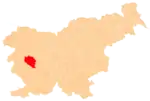
 Javornik Location in Slovenia | |
| Coordinates: 45°53′36.97″N 14°4′29.63″E / 45.8936028°N 14.0748972°E | |
| Country | |
| Traditional region | Inner Carniola |
| Statistical region | Gorizia |
| Municipality | Idrija |
| Area | |
| • Total | 7.46 km2 (2.88 sq mi) |
| Elevation | 1,139.9 m (3,739.8 ft) |
| Population (2014) | |
| • Total | 1 |
| [1] | |
Javornik (pronounced [ˈjaːʋɔɾnik]) is a small dispersed settlement on the slopes of Javornik Hill south of Črni Vrh in the Municipality of Idrija[2] in the traditional Inner Carniola region of Slovenia.[3] Its remoteness and high elevation have resulted in people moving away from their farms, and there is only a single resident in the settlement.
References
- ↑ Statistical Office of the Republic of Slovenia
- ↑ Idrija municipal site
- ↑ Leksikon občin kraljestev in dežel zastopanih v državnem zboru, vol. 6: Kranjsko. Vienna: C. Kr. Dvorna in Državna Tiskarna. 1906. p. 125.
External links
| Settlements | Administrative seat: Idrija
|  |
|---|---|---|
| Landmarks |
| |
| Notable people | ||
This article is issued from Wikipedia. The text is licensed under Creative Commons - Attribution - Sharealike. Additional terms may apply for the media files.