Kirkville, Louisiana | |
|---|---|
 Kirkville, Louisiana  Kirkville, Louisiana | |
| Coordinates: 30°59′44″N 90°28′42″W / 30.99556°N 90.47833°W | |
| Country | United States |
| State | Louisiana |
| Parish | Tangipahoa |
| Elevation | 243 ft (74 m) |
| Time zone | UTC-6 (Central (CST)) |
| • Summer (DST) | UTC-5 (CDT) |
| Area code | 985 |
| GNIS feature ID | 549695 [1] |
Kirkville is an unincorporated community in Tangipahoa Parish, Louisiana, United States. The community is located 1 mile (1.61 kilometres) S of Osyka, Mississippi and 18 miles (28.97 kilometres) N of Amite City, Louisiana
History
As German immigrants arrived at New Orleans they settled in Osyka, Mississippi and overflowed south into Louisiana. The land across the Louisiana state line was not a part of Mississippi and could not be called Osyka. The community took the name Kirkville and is named after Lawrence Alexander Kirk, a railroad surveyor that owned a large portion of the land.[2][3]
References
- ↑ U.S. Geological Survey Geographic Names Information System: Kirkville, Louisiana
- ↑ Debbie Cutrer Powers. "GERMAN CEMETERY, Tangipahoa Parish, Louisiana". LaGenWeb Archives. Retrieved August 21, 2019.
- ↑ Carol Monahan. "KIRKSVILE: Tangipahoa Parish". International Jewish Cemetery Project. Retrieved August 21, 2019.
Municipalities and communities of Tangipahoa Parish, Louisiana, United States | ||
|---|---|---|
| Cities | 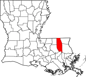 | |
| Towns | ||
| Villages | ||
| CDP | ||
| Other Unincorporated communities | ||
This article is issued from Wikipedia. The text is licensed under Creative Commons - Attribution - Sharealike. Additional terms may apply for the media files.